
U.S. Army Board of Engineers for Rivers and Harbors (sold)

The U.S. Army Board of Engineers for Rivers and Harbors (1902 - 1992) was a federal board that was part of the United States Army Corps of Engineers civil works program. Created by the Rivers and Harbors Bill of 1902, the board first fell under the War Department and then under the Department of Defense. The Water Resources Development Act of 1992 disestablished the Board of Engineers for Rivers and Harbors and transferred all its functions to the Chief of Engineers.
A look at Jacksonville's port facilities immediately after WWII.
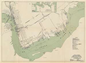
Port Facilities at Jacksonville, Florida.
sold
- Digital Map Information
- Suitable for large format printing
- File Size: 17.41 MB
- File Type: ZIP / TIFF
- ICC color profile embedded
- Delivered instantly via download link
This is a 1948 U.S. Army Board of Engineers for Rivers and Harbors and United States Maritime Commission map of the port of Jacksonville, Florida. Depicting port facilities along the St. John's River, over eighty docks, wharves, and piers are numerically identified and correspond with tables in the text. Other symbols identify warehouses. freight stations, lumber handling, fertilizer plants, dry docks, and other facilities. Streets along the riverfront are illustrated and labeled, along with several railroad lines. Alphabetic circles in the St. Johns River mark anchorages. An inset map of the St. Johns River from Jacksonville to Mayport appears at top center. (more details)