
Boazio, Giovanni Battista (sold)

Giovanni Battista Boazio (fl. 1588 – 1606) was an Italian draftsman and cartographer. A large part of his career was spent working in England, where he would produce maps of Ireland, the Isle of Wight, and an array of maps recording Sir Francis Drake's voyages to the West Indies. His map of Ireland would appear in Ortelius' Theatrum, while his Isle of Wight would provide Mercator with the source for his map of the island.
Anglesey, Wight and the Channel Islands from Contemporary Sources.
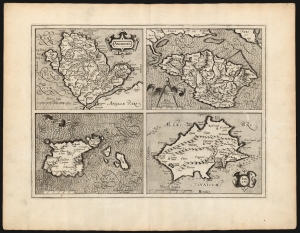
Anglesey/ Wight Vectis olim/ Garnesay/ Jarsey.
sold
- Digital Map Information
- Suitable for large format printing
- DPI: 600
- File Size: 53 MB
- File Type: ZIP / TIFF
- ICC color profile embedded
- Delivered instantly via download link
This is the 1595 first edition of Gerard Mercator's map of the Isle of Wight, Anglesey, Guernsey and Jersey. It was the first map to provide detailed focus on these islands to appear in a general atlas. All four maps are sharply detailed, with towns and topography indicated throughout; each individual map is provided its own scale, and each is titled within an elegant cartouche. The seas around Anglesey and Jersey are stippled, while those around Wight and Guernsey are hachured: the composition overall thus gives a pleasing checkerboard effect. (more details)