
Bouclet, Sébastien-François (sold)

Sébastien-François Bouclet (fl. c. 1800 - 1825) was a French engraver active in Paris in the late 18th and early 19th centuries. He engraved extensively for the Dépôt des Cartes et Plans de la Marine. Among those he taught is the Spanish engraver Felipe Cardano y Bauzá (1778 - 1824).
First accurate triangulation of the Faroes.
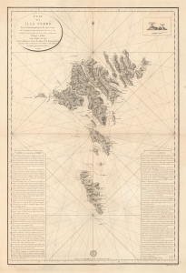
Plan des íles Ferøë Levé Géométriquement de 1790 à 1795...
sold
- Digital Map Information
- Suitable for large format printing
- DPI: 600
- File Size: 76.51 MB
- File Type: ZIP / TIFF
- ICC color profile embedded
- Delivered instantly via download link
This large and striking map is the 1820 French Dépôt des Cartes edition of the seminal 1806 Born survey of the Faroe Islands. This is the first map of the Faroes based on actual triangulation. Although formatted as a nautical chart, the map has little hydrographic detail, with the focus instead being on land-side topography and coastal settlements. (more details)