
Boudet, Antoine (sold)

Antoine Boudet (c. 1715 - 1787) was a shrewd business man and map publisher active in Paris, France during the latter part of the 18th century. Boudet was the stepson of Jean Baptiste Coignard, a royally appointed Parisian printer. In 1751 Boudet acquired roughly half of the Coignard firm and, on his own account, acquired a considerable fortune publishing the innovative periodical Petites Affiches. Boudet must have seen potential in that map and atlas market early on. Around 1746 - 1746 Boudet contracted the firm of Dheulland and Vallet to engrave large format forgeries of earlier maps by Guillaume Delisle and Jacques Nicholas Bellin - even going so far as hiring Bellin himself to update and revise the forgeries. This plan was stymied by a law suit brought against Boudet by Philippe Buache, who claimed the copyrights to Delisle's work. He later entered into a business arrangement with the prominent and well respected Parisian cartographer Gilles Robert de Vaugondy and financed several of Vaugondy's atlses, including the Atlas Portatif and the Atlas Universel. It was Boudet's keen business sense that made the production of the expensive and lavish Atlas Universel possible. He adopted a subscription system which partially paid for the atlas prior to the work's formal production. Boudet was later sued for non-payment by the engravers of the Atlas Universal, the Dalahaye firm. Moreover, Boudet's long lasting feud with Buache came back to haunt him when Buache, now an important and influential member of the Academie des Sciences, brutally and unnecessarily criticized the work. Boudet maintained offices on the Rue St. Jacques, Paris.
Uncommon map showing Jefferson's proposed states and the first map to name Michigan as a body of land.
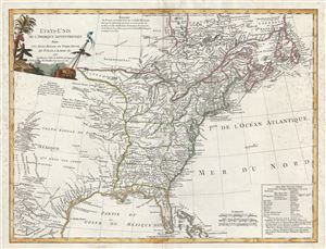
Etats-Unis De L'Amerique Septentrionale Avec Les Isles Royale, De Terre Neuve, De St. Jean, L'Acadie.
sold
- Digital Map Information
- Suitable for large format printing
- Full resolution TIFF file
- ICC color profile embedded
- Delivered instantly via download link
An uncommon and important first edition first state 1785 Antoine Boudet map of the fledgling United States shortly after the end of the American Revolutionary War. This map is important as one of the first, if not the first , to describe the 1784 Jeffersonian ... (more details)