
Brown, Harold Haven (sold)

Harold Haven Brown (June 6, 1869 - April 7, 1932) was an American artist, cartographer, illustrator, teacher, painter, and museum director. Born in Malden, Massachusetts, Brown attended the Massachusetts Normal Art School before heading to Paris, France to study with Jean Leon Gérôme at the École des Beaux-Arts and with J.P. Laurens at the Académie Julian. Brown also spent significant amounts of time studying museum work at the Louvre, the Musée de Cluny, and the Musée du Luxembourg. He married Florence Bradshaw, a fellow artist, on November 4, 1897. The couple lived in Chicago and then Indianapolis, where Brown served as the director of the John Heron Institute, holding the position from 1913 until 1921. They then moved to Provincetown, Massachusetts in 1923. Brown was a noted mapmaker, and also created woodcuts and watercolors. He also wrote books and articles on calligraphy and on decorative, pictorial, and mechanical drawing. He and Florence played an important role in the founding of the Provincetown Art Association and Museum and Brown served as its president from 1926 until his death in 1932. He and Florence had two children.
Highlights important Biblical and secular events throughout the region.
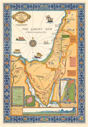
The Picture Map of the Holy Land.
sold
- Digital Map Information
- Suitable for large format printing
- File Size: 39.08 MB
- File Type: ZIP / TIFF
- ICC color profile embedded
- Delivered instantly via download link
This is a 1928 Harold Haven Brown pictorial map of the Holy Land / Israel and/or Palestine, including the Sinai, and parts of Egypte, Syria, Jordan, and Lebanon. The map depicts the region from the Nile River to Ammon (Syria) and from Tripolis (Tripoli), Lebanon to the Red Sea. (more details)
Holy and Secular.
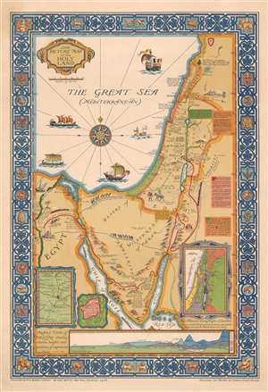
The Picture Map of the Holy Land.
sold
- Digital Map Information
- Suitable for large format printing
- File Size: 34.11 MB
- File Type: ZIP / TIFF
- ICC color profile embedded
- Delivered instantly via download link
This is a 1928 Harold Haven Brown pictorial map of the Holy Land / Israel and/or Palestine, including the Sinai, and parts of Egypt, Syria, Jordan, and Lebanon. The map depicts the region from the Nile River to Ammon (Syria) and from Tripolis (Tripoli), Lebanon to the Red Sea. (more details)