
Burnham, Graham (sold)

Graham Burnham (fl. c. 1890 - c. 1920) was an American real estate developer, author, and surveyor. Burnham published a book entitled Wheaton and its Homes in 1892, the same year this map was published. His brother, Daniel Burnham, was a successful architect in Chicago who designed the 1893 Chicago World's Fair.
A real estate map of Wheaton, Illinois featuring a profile illustration of Wheaton College.
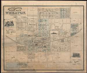
Prout and Burnham's Official Map of Wheaton, Dupage County Illinois.
sold
- Digital Map Information
- Suitable for large format printing
- File Size: 46.91 MB
- File Type: ZIP / TIFF
- ICC color profile embedded
- Delivered instantly via download link
Created as a promotional piece to entice city dwellers to move to Wheaton, this rare 1892 Charles A. Prout and Graham Burnham city plan or map of Wheaton, Illinois, is divided into lots, with numerous different 'additions' identified. Depicting the city from Carleton Avenue (modern-day N. Carlton Street) to President Street and from Prairie Avenue to the Chicago and Batavia Road (modern-day Roosevelt Road), streets throughout town are illustrated and labeled. Profile sketches of Wheaton College, the Court House, the schoolhouse, and both train depots are included, as are small pictorial icons marking the sites of the city's churches. The Chicago and Northwestern Railway arcs across town, splitting the town in half. Profile illustrations of Adam's Memorial Library and Central Block are situated around the map. (more details)