
Cabrer, Jose Maria (sold)

Jose Maria Cabrer (1761 - 1836) was a Spanish military engineer and geographer. Born in Barcelona, the son of a military engineer Carlos Cabrer y Suñer. He studied engineering at the Royal Academy, and was a student of cartographer Félix de Azara (as well as his own father.) With the onset of the American Revolution, he set aside the academy to join Spanish naval efforts to support America against the British Empire. Initially targeted at Jamaica, he was sent instead to the Buenos Aires as attaché of the Royal Corps of Engineers to assist in demarcating the boundary of Spanish territory in South America with Brazil. He arrived there in 1781, then completing his training as a cartographer. In 1783, with the military rank of Captain, he surveyed the border region of the Banda Oriental, which would largely become Uruguay. He would become a commissioner and geographer of the second demarcation party under Diego de Alvear, reconnoitering the Paraná River and the course of the Uruguay River. In 1789, he surveyed the Pepirí Guazú River, the middle of the border set by the Treaty of San Ildefonso (1777). He returned to Buenos Aires as a Lieutenant Colonel in 1801, where he would choose to stay upon learning of the deaths in Spain of his father and brothers. He settled and married a barber's daughter over the objections of his superiors, who thought the match below him. The following twenty years seem to have been, politically, poorly navigated: following the Revolution of 1810 he was appointed to direct a mathematics academy, but the project did not proceed; he would be appointed secretary to the Argentine General Staff, but he refused the position. In 1831 following the estblishment of the Argentine Confederation, he accepted a posting to the Topographical Department, but did not enjoy the position long: He died in 1836 as the result of an improperly prescribed medicine. Although many of his boundary commission maps would be published, his superb 1802 he map of the La Plata region, including Uruguay and Paraguay, would not be published until 1853 in a Paris edition.
Highlighting Brazilian Transgressions in the Banda Oriental.
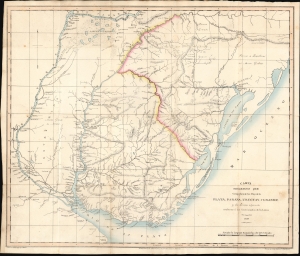
Carta Geografica que Comprehende los Rios de la Plata, Paranà, Uruguay, y Grande y los Terrenos adyacentes conforme a' los Comisionados de la Linea de limites 1820.
sold
- Digital Map Information
- Suitable for large format printing
- File Size: 15.73 MB
- File Type: ZIP / TIFF
- ICC color profile embedded
- Delivered instantly via download link
This is an 1825 map of the lands comprising present-day Uruguay, produced anonymously by Argentinian diplomat Ignacio Núñez to garner European support for the United Provinces of the Río de la Plata in the Cisplatine war against the Empire of Brazil. While the mapmakers are unnamed, the map draws on the work of Spanish border commissioners and engineers Félix de Azara, Jose Maria Cabrer, and others. It presented to a European audience the frontier agreed upon in the 1777 Treaty of Ildefonso between the Spanish and Portuguese Empires in South America - thus emphasizing that Brazil's invasion occupation of Montevideo was a breach of treaty. (more details)
Historical Justifications for Argentinian Territorial Claims in La Plata.
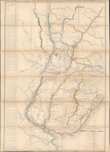
Carta esferica de la confederacion Argentina y de las republicas del Uruguay y del Paraguay.
sold
- Digital Map Information
- Suitable for large format printing
- File Size: 47.3 MB
- File Type: ZIP / TIFF
- ICC color profile embedded
- Delivered instantly via download link
This is the sole edition of Jose Maria Cabrer's 1826 map of the Argentine Confederation, Paraguay, and Uruguay, based on his surveys executed between 1777 and 1802. Despite its excellence, it was not published during the author's lifetime and did not appear in print before this Paris edition of 1853. The original manuscript has not survived. Cabrer, a Spanish military engineer, had been assigned to survey the borders of the Spanish and Portuguese empires in South America following the 1777 Treaty of Ildefonso; the present work encapsulates two decades of arduous, well-respected surveys, compiled 'unofficially' by Cabrer in 1802. (more details)