
Chandler, Henry (sold)

Henry Chandler (February 23, 1830 - December 21, 1896) was a Buffalo based engraver, lithographer, and artist active in the mid to late 19th century. Chandler was born in Springfield, Massachusetts, the descendent of William Chandler of Andover, one of the oldest families in the United States. Chandler was born wealthy, but his family wealth was lost in the Panic of 1837. After the loss, he relocated with his family to Seneca County, New York. He was here that he developed his artistic talent, supplementing teaching at the local public school (he was just 15) with sign painting. Chandler relocated to Buffalo, New York in 1850, when he was 20, taking work as a typesetter with the Commercial Advertiser and Journal, a local paper. There, it is claimed he invented wax process engraving - an exceptionally economical printmaking technique that would become popular in the latter 19th century. In 1856 Chandler and his brother Frank Chandler, jointly founded their own engraving and printing enterprise. The business proved successful. They received considerable business from the railway industry, which required copious cost-effective printing, including maps, timetables, and advertising flyers. In 1862, the Chandler brothers partnered with Elam Richardson Jewett (1810 - 1887) to form 'Jewett and Chandler' with the goal of perusing larger government printing contracts. They were successful in securing patent office contracts as well as mapping contracts. Their work drew the attention of the William P. Northrup (1850 - 1910) and James N. Matthews (1828 - 1888) of the Matthews-Northrup Company, which acquired Jewett and Chandler in 1874. Chandler died in 1896 in Buffalo, New York.
A glimpse at the Mount Desert 'Rusticator' life.
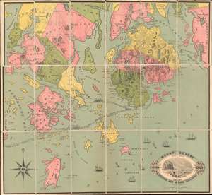
Mount Desert Direct Route vis Boston and Maine Railroad
sold
- Digital Map Information
- Suitable for large format printing
- File Size: 25.42 MB
- File Type: ZIP / TIFF
- ICC color profile embedded
- Delivered instantly via download link
A very scarce chromolithograph map, here dissected and laid on linen, covering Mount Desert Island, Blue Hill, Deer Isle, and vicinity, issued around 1880 for the Boston and Maine Railroad. Geared toward the 'Rusticator' crowd, this map illustrates ferry connections between Mount Desert Island and Rockland, Portland, Lewiston, Milbridge, and more. Although long predating the founding of Acadia National Park, this map offers a unique glimpse into the 'Rusticator' lifestyle - referring to seasonal Mount Desert enthusiasts, both men and women, who gathered on the island in summer months to enjoy the rigorous hiking, climbing, and scenic views. The Boston and Maine Railroad is promoted on the lower left, along with an engraved view of Great Head, a rocky promontory south of Bar Harbor. (more details)