
Childs, Orville Whitmore (sold)

Orville Whitmore Childs (December 29, 1803 - September 6, 1870) was an American civil engineer and surveyor active in New York State during the middle part of the 19th century. Childs worked on the Champlain Canal (1824 - 1825), the Oswego Canal (1826 - 1828), and navigational impor9vment to the Oneida River (1829 - 1830). In 1840, he was appointed chief engineer for New York City, a position he held until 1847. He was the Democratic candidate for the office of State Engineer in 1848. He is known to have worked with other significant civil engineers in New York, including John D. Fay, Ver R. Richmond, and Sylvanus H. Sweet. He left Civil Service in 1848 to work as Chief Engineer for the construction of the New York Central Railroad from Syracuse to Rochester. In 1850, he became involved with Cornelius Vanderbilt's American Atlantic and Pacific Ship Canal Company's attempt to build an interoceanic canal through Nicaragua. When efforts to build a Nicaragua canal got sidetracked, he became chief engineer of the Terre Haute and Alton Railroad, a position he held from 1855 to 1858. In the 1860s he returned to work for New York State, completing a survey to determine the limits and boundaries of the city of New York.
Who owns New York City? City or State?
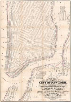
New Map of that Part of the City of New York south from 20th Street on the Hudson and 35th Street on the East River.
sold
- Digital Map Information
- Suitable for large format printing
- File Size: 45.27 MB
- File Type: ZIP / TIFF
- ICC color profile embedded
- Delivered instantly via download link
This is a rare map drawn to settle a land rights dispute between New York City and New York State. The map extends from roughly 32nd street to the Battery and includes the shorelines of Brooklyn and Queens. It illustrates the city's street grid, showing all piers and docks, ferry lines, and the pier line. Most importantly, it illustrates the cities original boundary line, noting both the high and low water marks (this was one of the maps consulted by Egbert Viele to produce the famous 1865 Waterways Map). More importantly, it illustrates the shore boundaries of Manhattan and Brooklyn according to the various surveys and charters completed between 1735 and 1808. (more details)