
Colijn, Michiel (sold)

Michiel Colijn (October 29, 1584 - September 23, 1637) was a Dutch printer and publisher active in Amsterdam during the late 16th through the early 17th centuries. Most of his work was issued between 1608 and 1635. Colijn was a student and employee of the printer, publisher, and bookseller, Cornelius Claesz (1560-1609). After Claesz died in 1609, his printing plates and other professional affects were sold at auction in 1610. Most of these were acquired by Colijn, who used them as the basis of his own publishing house.
The first map to show California as an Island!
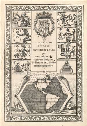
Descriptio Indiae Occidentalis per Antonium de Herrera.
sold
- Digital Map Information
- Suitable for large format printing
- DPI: 600
- File Size: 11.42 MB
- File Type: ZIP / TIFF
- ICC color profile embedded
- Delivered instantly via download link
This seminally important 1622 map is considered the first to illustrate California as an Island. This map is actually part of the title page of the Michiel Colijn expanded edition of Antonio de Herrera y Tordesillas's Descriptio Indiae Occidentalis. The map, appearing at bottom center, is simple but masterfully engraved. It argues for three important and revolutionary ideas:
- California as an Island An open Northwest Passage
- A large river just north of California