
J. Damilano (sold)
Best map of Alexandria of the 19th century.
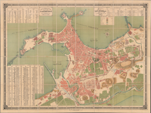
Direction Générale du Tanzim Plan de la Ville D'Alexandrie Dressé à l'Inspection de L'Ouest. / إدارة عموم التنظيم. خريطة مدينة الإسكندرية
sold
- Digital Map Information
- Suitable for large format printing
- Full resolution TIFF file
- ICC color profile embedded
- Delivered instantly via download link
This is a monumental 1887 Arabic and French administrative plan of Alexandria, prepared by the Egyptian Tanzim, the largest and most important map of Alexandria printed in the 19th century. The map records the city's streets, institutions, and government property in the early years of British occupation. Its extensive bilingual indexes turn a building-level survey into a working directory of the city, distinguishing private buildings from state establishments, religious institutions, and baths. The inventory of government property is particularly revealing, identifying destroyed fortifications and buildings occupied by British soldiers. The map brings together Alexandria's commercial infrastructure, religious communities, and altered military geography in a single official document. (more details)