
Dressen, Louis (sold)

Louis Dressen (19?? - 1972) was an architect, bank manager, and businessman. Born in Bielefeld, Germany, at some point Dressen moved the Liège, Belgium, and then moved on to Zanzibar. While in Zanzibar, he worked as a manager of a Belgian bank before moving to Katanga, in the Belgian Congo, in 1925. For a while he worked as the manager for the Elisabethville Banque du Congo Belle. He also worked as a businessman for several companies, including Carrières de la Karavia, Les Bureaux Modernes, and the Plantations de Dilolo). Dressen created several city maps, maps of Katanga, and even the armorial bearings of Elisabethville and some local schools. He died in Lubumbashi (formerly known as Elisabethville) in 1972.
Igniting the Congo Crisis.
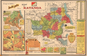
Etat du Katanga. Le pays du bonheur. Inchi yetu. Notre pays.
sold
- Digital Map Information
- Suitable for large format printing
- DPI: 600
- File Size: 61.2
- File Type: ZIP / TIFF
- # of Files: 1
- ICC color profile embedded
- Delivered instantly via download link
This is a c. 1960 Louis Dressen map of the State of Katanga, a secessionist region of the Congo, published in Elisabethville, Katanga's capital. Katanga's secession ignited the Congo Crisis and ultimately led to the dictatorship of Mobutu Sese Seko. (more details)