
Eddy, John H. (sold)

John H. Eddy (1784 - December 22, 1817) was an important yet tragic figure in New York cartography during the early 19th century. Eddy referred to himself as a 'Geographer' and is responsible for drafting a number of important maps of New York, including the most accurate mappings in his day of western New York and of the vicinity of New York City. Little is known of Eddy's early life. Eddy was raised in New York and educated in public schools until, before graduating, he contracted scarlet fever. The illness rendered him deaf and unable to continue on a traditional educational path. Instead Eddy dedicated himself to studies of cartography, mathematics, and drafting, fostering friendships and maintaining an active correspondences with leading figures in these fields. Around this time he also developed an abiding love of the outdoors. Eddy published his first maps in 1811 and 1812. These included his important map of Western New York as well as a highly detailed map of the area 30 miles around New York, known today as "The Eddy Map". Impressed with his work, New York Governor Dewitt Clinton commissioned him to compile several important maps of the Erie Canal and the Niagara River as well as a large format map of New York State. Eddy finished compiling this work in 1817 shortly before his mysterious and sudden December 22 death. Eddy's last map was published posthumously in 1818. At the time Eddy is also known to have been in the process of compiling an America atlas in association with Tanner, Vallance, Kearny and Co. of Philadelphia.
The Eddy Map.' One of the most important early maps of New York City ever printed.
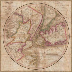
Map of the country Thirty Miles Round the City of New York.
sold
- Digital Map Information
- Suitable for large format printing
- DPI: 300
- File Size: 15.89 MB
- File Type: ZIP / TIFF
- ICC color profile embedded
- Delivered instantly via download link
Known as 'The Eddy Map,' this is an extremely rare and important circular map of New York City and vicinity, dated 1823. Covers the New York City area in roughly a thirty mile radius of Manhattan, extending north to Tarrytown, south to Monmouth, west to Somerset, ... (more details)