
Foot, Thomas (sold)

Thomas Foot (fl. 1790 - 1825) was a British map engraver active in London around the turn of the 18th century. Foot apprenticed to Garnet Terry of the Tinplate Workers. He was the son of William Foot, a stable keeper based on Chapel Street, Grosvenor Square, London. Foot engraved extensively for the Ordnance Survey from about 1801 to 1804, when he was imprisoned for debt. In addition to his work with the Ordnance Survey, Foot also engraved for Robert Wilkinson, William Faden, Aaron Arrowsmith, James Colnett, and many others.
One of the first maps to detail the 1788 British colonization of New South Wales, Australia.
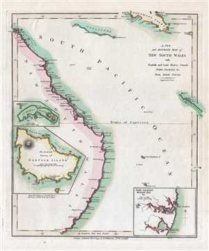
A New and Accurate Map of New South Wales with Norfolk and Lord Howes Islands Port Jackson and C. from Actual Surveys.
sold
- Digital Map Information
- Suitable for large format printing
- DPI: 300
- File Size: 1.41 MB
- File Type: ZIP / TIFF
- ICC color profile embedded
- Delivered instantly via download link
A finely detailed first edition 1794 map of the New South Wales, Australia, by Robert Wilkinson. One of the first maps to detail the British colonization of Australia, Wilkinson’s map covers eastern Australia from the endeavors Straits south as far as Furneaux ... (more details)