
Geelkercken, Nicolaes van (sold)

Nicolaes van Geelkercken (ca. 1585 - 1656) was a Dutch surveyor, cartographer and publisher active in the early 17th century. He is thought to have begun his work as a cartographer, engraver, and colorist in the shop of Jodocus Hondius. Starting in 1610, he began producing maps to illustrate current conflicts of interest. In order to ensure that his news maps were up to date and accurate, Geelkercken was known to accompany the Dutch army on campaign. He was succeeded in his trade by his sons Isaac van Geelkercken, Jacob van Geelkercken and Arnold van Geelkercken.
One of the most unique world maps of the 17th century.
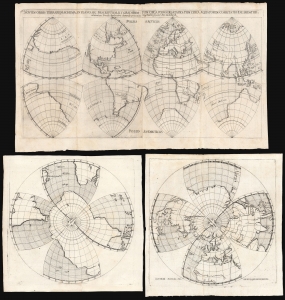
Novum orbis terrarum schema, in plano sic descriptum, ut graduumtum circa polos dilatatio, tum circa aequatorem coarctatio excludatur.
sold
- Digital Map Information
- Suitable for large format printing
- Full resolution TIFF file
- ICC color profile embedded
- Delivered instantly via download link
This rare, dual world map, projected in octants by Daniel Angelocrator in 1628, is among the most unique and distinctive 17th century depictions of the world. (more details)
The Finest Dutch World Map Venice Could Offer.
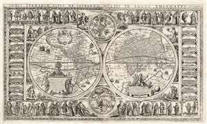
Orbis Terrarum Tipus de Integro Multis in Locis Emendatus.
sold
- Digital Map Information
- Suitable for large format printing
- Full resolution TIFF file
- ICC color profile embedded
- Delivered instantly via download link
This beautiful, extremely rare, separately-issued, double hemisphere carte á figures world map captures the most desirable elements of 17th century Dutch decorative cartography in one composition - including an Amsterdam imprint and the prominently displayed patronym of 'Willem Blaeu'. Both the imprint and the professed authorship were deliberately misleading: the map was engraved in Venice, not Amsterdam, and it has been attributed to the illustrator and printer Stefano Mozzi Scolari. The map is dated 1655. It is perhaps ironic that of the Dutch mapmakers from whom Scolari sourced this map, not one element appears to have been drawn from Blaeu, apart from his name. The engraver was not fully committed to deception: faintly in the lower right border is an additional, more honest imprint, 'in Venetia à S. Fosca'. Bifolco identifies this location as an engravers' shop associated with Scolari. (more details)