
Glover, Eli Sheldon (sold)

Eli Sheldon Glover (August 14, 1844 - May 29, 1920) was an American inventor, publisher, and artist of perspective maps, also known as bird's-eye views. Glover is remembered as one of the great artists of the golden age of American bird's-eye views. Over the course of his career, Glover produced views of many Midwestern and Western cities in the U.S. and Canada and worked in Chicago, San Francisco, and Tacoma. He started his career in Ypsilanti, Michigan, working for Albert Ruger, where he was primarily a salesman. Two years later, he moved to Chicago, where he established the Merchants Lithographing Company. Unfortunately for Glover, his first foray into business for himself ended quickly, when the Merchants Lithographing Company was destroyed by the 1871 Great Chicago Fire. Glover then began roaming around the country, producing views of the areas through which he traveled. In 1872 - 1873, Glover produced views of Colorado. He lived in Salt Lake City in 1874, and used the city as a base of operations, traveling and creating views in Wyoming, Utah, and Montana. Glover and his wife lived in Los Angeles in 1876 and 1877, and Glover produced sixteen views of different California cities over these two years. Late in his career, Glover designed and manufactured a prospector's drill that was used in Alaska. He also operated a binder and notebook business. While the majority of his artistic output was lithograph city views, he was also an accomplished painter and created many fine landscape canvases during his lifetime.
A rare real estate advertisement from 1930s Santa Barbara.
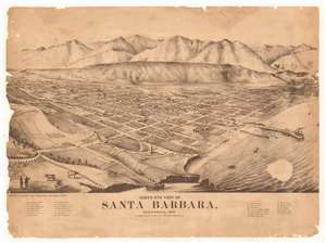
Bird's Eye View of Santa Barbara, California.
sold
- Digital Map Information
- Suitable for large format printing
- File Size: 36.42 MB
- File Type: ZIP / TIFF
- ICC color profile embedded
- Delivered instantly via download link
This is a c. 1930 Sunset County Realtors photolithographic bird's-eye view advertising broadside map of Santa Barbara, California. Looking north toward the Santa Barbara Mountains, streets appear as wide thoroughfares populated by horseback riders and people. Twenty-seven locations around town are numerically identified and correspond to an index along the bottom border. These include Santa Barbara College, over half a dozen churches, the National Gold Bank, the Quicksilver Mine, and the Independent Order of Oddfellows (I.O.O.F.) Hall and Library. Two large ships, one a three-mast sailing ship and the other a 'modern' steamship, are illustrated docked to a large pier, while several smaller craft, mostly sailboats, crowd the water near the smaller pier. (more details)