
Goldthwait, Jonathan Hale (sold)

Jonathan Hale Goldthwait (May 21, 1811 - January 26, 1870) was an American engraver and publisher. Born in Longmeadow, Massachusetts, to Hannah and Erastus Goldthwait, he went to Boston to apprentice with a bank note engraver at the age of seventeen in 1828. He stayed in Boston until at least March 1834. He resurfaced in Springfield, Massachusetts, where he engraved a wall map of Springfield for his cousin George Colton (1793 - 1839). Charlotte Goldthwaite, in her genealogy of the Goldthwaite family, described Jonathan Hale Goldthwait as 'an artist in temperament, possessing a very intuitive sense of the beautiful and of the incongruous, and his fine taste and excellent judgment in such matters were very much sought and valued'. Another genealogy describes Goldthwait in this manner, 'He was a man of fine artistic temperament, a very expert copper-plate map engraver, and without an equal in the branches of small lettering and cutting 'rippled water', both as to rapidity and effect. He was also a good musician, and for many years played upon the organ in some leading church, where he was at the time residing.' Goldthwait married Susan Loud Joy on November 17, 1840, with whom he had three children.
Highlights the burgeoning railroad network in New England.
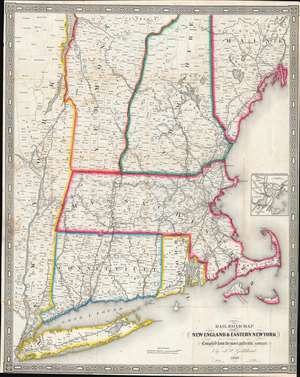
Railroad Map of New England and Eastern New York.
sold
- Digital Map Information
- Suitable for large format printing
- Full resolution TIFF file
- ICC color profile embedded
- Delivered instantly via download link
This is an 1849 J.H. Goldthwait railroad map of New England, depicting from the Hudson River to the Atlantic coast. The map features featuring striking outline color, tracing railroad routes throughout Massachusetts, Connecticut, Rhode Island, Vermont, New Hampshire, and eastern New York. Among the railroads are the Boston and Maine Railroad; the Eastern Railroad; the Boston and Providence Railroad; the New York, New Haven, and Hartford Railroad; the Long Island Railroad; and the Hudson River Railroad. An inset along the right border focuses on Boston and its immediate vicinity and illustrates the area's railroads, including the Grand Junction Railroad. (more details)
Short-lived Confederate State of Arizona.
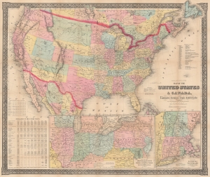
Goldthwait's Map of the United States and Canada, exhibiting the Railroads with their distances, single and double tracks and width of gauge.
sold
- Digital Map Information
- Suitable for large format printing
- File Size: 128.17 MB
- File Type: ZIP / TIFF
- ICC color profile embedded
- Delivered instantly via download link
Produced in the early days of the U.S. Civil War, this is Jonathan Hale Goldthwait's 1861 map of the United States and Canada. Highlighting matters of military importance, including railroads, ports, and the proportion of enslaved people in each state, it is notable for its inclusion of the Confederate Arizona Territory, a short-lived attempt to extend slaveholding territory beyond Texas and increase Confederate influence in the American West. (more details)