
Hoffmann, Johann (sold)

Johann Hoffmann (1629-1698) was a German publisher of books and maps, based in Nuremberg. Nothing is known of his background apart from his work. His cartographic output mostly consisted of pirate editions of the Sanson and DuVal quarto atlases, but he did produce several notable maps during his career: 1664 Neűe Ungarisch- und Türckische Grosse Land-Charte, plans of Nuremberg and Vienna, and a unique and up-to-date 1691 map focusing on French military successes in the Alsace-Lorraine region. Most of his career was spent in Nuremberg, but he appears to have traveled earlier on. His 1677 map of the Alsace from Basel to Speyer was a collaboration with Swiss mathematician and cartographer Georg Friedrich Meyer (1645 - 1693), and was produced in Basel; it is not known whether this was a limited tenure or was representative of an extended period spent there.
Documenting and propagandizing a scorched-earth campaign in the Nine Years' War.
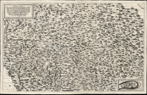
New Inventirte Land Carte Eines theil des Königreichs Franckreichs und darinn gelegenen Vornemsten Stätt und Vestungen: Samt deßen Conquesten Lothring, Franche Conte, Elsas, Pfaltz am Rhein, Mosel-Strohm und in NiderLand: Wie auch des angrentzende Saphoyen, Piemont, Schweitz, Schwartzwald, Würtenberg, Pfaltz am Rhein, und Wetterau, und angelegnen Ländern.
sold
- Digital Map Information
- Suitable for large format printing
- File Size: 39.6 MB
- File Type: ZIP / TIFF
- ICC color profile embedded
- Delivered instantly via download link
This is a 1691 proof state of Johann Hoffman's large, beautiful, and rare separately-issued map of France's frontiers during the Nine Years' War (1688 - 1697), produced as part of an anti-French propaganda scheme at the height of Louis XIV's scorched earth campaign. As described in the map's title, the map portrays part of France, 'Including its Conquests of Lorraine, Franche-Comté, Alsace, the Palatinate on the Rhine, the Moselle-Strohm, and the Netherlands...' The map details the heavily-fortified French border extending from the port of Dunkirk to the German frontier along the Rhine River, then to the frontiers of Switzerland, Piedmont, and Savoy: a defensive front stretching from the English Channel to the Mediterranean. (more details)