
Jacoby (sold)

Jacoby (fl. c. 1897 - 1910) was a German military officer and surveyor active in Tsingtao (Qingdao), China, in the late 19th and early 20th centuries. He is identified in China Directories as a 'Katasterzeichner' or 'Cadastral Draughtsman' attached to the Tsingtao (Qingdao) colonial administration.
Joint work by Chinese and German surveyors.
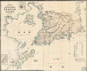
Ostasien-Schantung Deutsches Schutzgebiet Kiautschou 德属膠澳全圖 gezeichnet nach der von der Vermessung Kiautschou 1898/99 augenommenen topographischen Karte und nach eigenen Aufnahmen im Landamt Kiautschou, 1907.
sold
- Digital Map Information
- Suitable for large format printing
- File Size: 57.16 MB
- File Type: ZIP / TIFF
- ICC color profile embedded
- Delivered instantly via download link
A rare and important 1907 zincographic map of Kiautschou Bay Concession, Qingdao / Tsingtau, compiled by a joint German-Chinese team led by Jacoby. This was an official map issued in Qingdao for official use. The map covers most of what is today Qingdao, Shandong, China (青岛市), embracing Jiaozhou Wan (Kiautschou Bay), and the surrounding territories. Place names appear both in English and Chinese - reflecting the fact that this map was made jointly by Jacoby and two Chinese surveyors, draughtsman Yang Kebin (杨可斌) and translator Gao Jingtao (高景陶). The city Tsingtau (meaning 'Green Island' in German) is here laid out, consisting of a German quarter to the south and a Chinese quarter (the original fishing village) to the north. The expansive harbor, constructed around the now-famous Zhanqiao Pier (青岛栈桥), was the heart of the colony, facilitating both maritime trade and German naval activity. (more details)