
Kankōsha (sold) (觀光社)

Kankōsha (觀光社; c. 1918 – 1955), initially named Taishō Meisho Zuesha (大正名所圖繪社), was a Japanese publisher specializing in bird's eye views of famous scenic and tourist sites in Japan, especially sketchbook mailer maps (書簡圖繪). They regularly published works by with Yoshida Hatsusaburō (吉田初三郎), a master of the genre.
AKA: 觀光社
A scenic view from the heart of Japan.
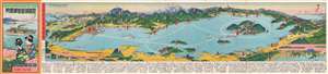
琵琶湖遊覽御案内 / [Lake Biwa Round Trip].
sold
- Digital Map Information
- Suitable for large format printing
- Full resolution TIFF file
- ICC color profile embedded
- Delivered instantly via download link
This is a scarce and beautiful 1926 bird's-eye view of Lake Biwa by Yoshida Hatsusaburō, the greatest master of his day in the genre. More specifically, it belongs to the category of sketchbook mailers (書簡圖繪), brochure-like folding views of famous sites in Japan that were very popular in the 1920s–1940s. (more details)
Standout work by Japan's paramount view artist.
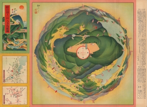
叡山頂上一目八方鳥瞰圖 / [Multi-Directional Bird's-Eye View from the Peak of Mt. Hiei].
sold
- Digital Map Information
- Suitable for large format printing
- File Size: 18.52 MB
- File Type: ZIP / TIFF
- ICC color profile embedded
- Delivered instantly via download link
An unusual c. 1926 view depicting a 360-degree perspective from the peak of Mt. Hiei, near Kyoto, Japan. It was produced by Yoshida Hatsusaburō, a master of the bird's-eye view, though it differs significantly from most of Yoshida's other works. (more details)
Korea by Japan's Master Viewmaker.
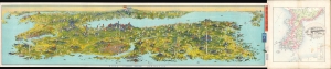
朝鮮大圖繪 / [Large Drawn Map of Korea].
sold
- Digital Map Information
- Suitable for large format printing
- Full resolution TIFF file
- ICC color profile embedded
- Delivered instantly via download link
This large and visually stunning view of the Korean Peninsula was drawn by Yoshida Hatsusaburo and published by the Wonsan Daily News (元山毎日新聞社). It was produced to coincide with the Chōsen Exhibition, a celebration of the 'benefits' Japanese rule had brought to Korea. The view is also significant because it is among the earliest published views by Yoshida of areas outside the Japanese home islands, a focus that would become more pronounced in his work in the following years as Japan's empire expanded. (more details)