
Lazaridou, Herakles (sold) (Ηρακλέους Λαζαρίδου)

Herakles Lazaridou (Ηρακλέους Λαζαρίδου; fl. c. 1852 – 1877) was a Greek cartographer and publisher active in the mid-late 19th century. Nothing is known of his biography and very little of his oeuvre, but his most important work looks to have been a Geographic Atlas (Γεωγραφικός άτλας), published in at least two editions in the 1860s.
AKA: Ηρακλέους Λαζαρίδου
One of the only maps to name the proto-Texan freebooter 'Republic of Fredonia'. And it's in Greek.
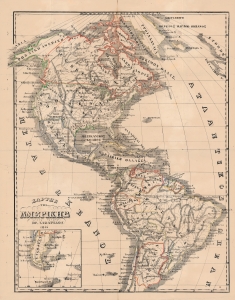
Χαρτησ τησ Αμερικησ / [Map of America].
sold
- Digital Map Information
- Suitable for large format printing
- File Size: 29.47 MB
- File Type: ZIP / TIFF
- ICC color profile embedded
- Delivered instantly via download link
This is a rare hand-colored 1866 Greek-language map of the Americas, produced by Herakles Lazaridou. Although entirely in Greek, this map is fascinating as one of the few maps to name the 'Republic of Fredonia' (1826 - 1827), a short-lived freebooter state in Texas. (more details)