
Lincoln Highway Association (sold)

The Lincoln Highway Association (1913 - 1927 ; 1992 - present) was originally established 'to procure the establishment of a continuous improved highway from the Atlantic to the Pacific, open to lawful traffic of all description without toll charges'. Organized on July 1, 1913, with the ultimate goal of raising ten million dollars for construction of the Lincoln Highway, which was first known as the 'Coast-to-Coast Rock Highway'. The original proposal called for the organization to raise contributions from automobile companies and in hundred-dollar and five-dollar donations from private individuals. The money would then be used to purchase road materials, such as concrete and gravel, which would then be provided to state and county highway authorities, who would in turn provide the labor and machinery necessary to build the highway. The group was disbanded in 1927, following the creation of the highway numbering system, as the Lincoln Highway lost its name and the transcontinental route was broken up into several different numbered highways. The group was restarted in 1992 with the goal of preserving the highway and its heritage.
An early map of the Lincoln Highway - the first transcontinental highway in the United States.
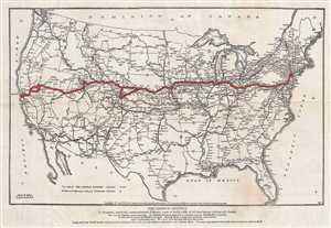
The Lincoln Highway.
sold
- Digital Map Information
- Suitable for large format printing
- File Size: 4.67 MB
- File Type: ZIP / TIFF
- ICC color profile embedded
- Delivered instantly via download link
This is a 1913 Lincoln Highway Association and American Automobile Association map of the proposed route for the Lincoln Highway, what would become the first transcontinental automobile road and the first national memorial to Abraham Lincoln. The map depicts the continental United States from the Pacific Ocean to the Atlantic Ocean and from Canada to Mexico. Highlighted in red and marked by diagonal lines, the original route for the Lincoln Highway stretches from New York to San Francisco and includes the 'Colorado Loop' that was removed from the route a few years later. Numerous other highways are illustrated, and those that are believed to be 'natural tributaries' are indicated by parallel lines drawn through those highways. Myriad cities, towns, and villages are labeled from coast to coast, as are major rivers, lakes, and mountain ranges. (more details)