
Lotharingia, Paulus a (sold)

Paulus a Lotharingia (fl. c. 1750 - 1760) was a Capuchin priest and engraver active in northern Italy in the mid 18th century. We see just two or three works bearing his imprint, typically 'F.P. a Lothar. Cap.'
Piedmontese Easter - a Massacre of Waldensians in the Europe Wars of Religion.
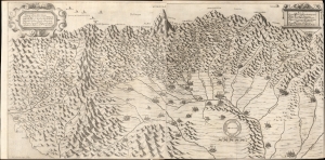
Topografica descrittione d'Alcune singolari Città in pian, e Valliprincipali nelle Alpi, per le quali come Porte del Italia dal Piemonte sipassa in Provenza, Delinato, Savioa, e Vallei, nelle quali resiedono la Missioni de PP. Capuccini.
sold
- Digital Map Information
- Suitable for large format printing
- File Size: 28.98 MB
- File Type: ZIP / TIFF
- ICC color profile embedded
- Delivered instantly via download link
This exceptional piece is the 1659 Paulus a Lotharinga map of the Italian Alps issued to illustrate ongoing efforts to suppress the Waldensians (Valdesi) sect in the wake of the 1655 'Piedmontese Easter' or the 'Massacre of the Waldensians' - one of the darkest episodes in the European Wars of Religion. It is known in academic circles as the Carta dei Cappuccini or 'Capuchin Map'. (more details)