
Lowry, Joseph Wilson (sold)

Joseph Wilson Lowry (October 7, 1803 – June 15, 1879) was an English engraver active in London during middle to later 19th century. Joseph was the son of Wilson Lowry (1760 – 1824), also an engraver under whom he apprenticed. Lowry produced numerous important maps for other publishers and even introduced his own atlas, Lowry's Table Atlas, in 1852. He was appointed engraver to the Geological Survey of Great Britain and Ireland.
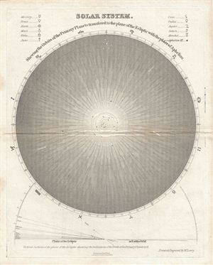
Solar System.
sold
- Digital Map Information
- Suitable for large format printing
- DPI: 300
- File Size: 2.94 MB
- File Type: ZIP / TIFF
- ICC color profile embedded
- Delivered instantly via download link
This is a fine example of W. Lowery's c. 1840 Lowry map of the Solar System. The map shows the orbit of the primary planets transferred to the plane of the ecliptic with the place of aphelion. The upper left and right quadrant contains a key identifying the ... (more details)
Roots of Russian Revanchism.
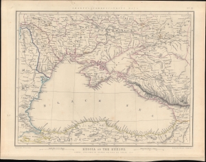
Russia on the Euxine. Sharpe's Corresponding Maps No. 22.
sold
- Digital Map Information
- Suitable for large format printing
- DPI: 600
- File Size: 296.83 MB
- File Type: ZIP / TIFF
- ICC color profile embedded
- Delivered instantly via download link
This is J. Sharpe's 1847 map of the Black Sea region issued for Sharpe's Corresponding Atlas. It presents 'The Eastern Question', reflecting political tensions related to ongoing wars between the Ottoman and Russian empires. (more details)
The first scientific map of Jerusalem made during the Oriental Incident of 1840.
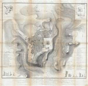
Plan of the town and environs of Jerusalem: Copied by Permission of Field Marshal the Marquis of Anglesey, K.G. G.C.H. Master General of the Ordnance, from the original drawing of the survey made in the month of March 1841.
sold
- Digital Map Information
- Suitable for large format printing
- DPI: 300
- File Size: 31.59 MB
- File Type: ZIP / TIFF
- ICC color profile embedded
- Delivered instantly via download link
This seminal 1849 map, printed on linen, is the first scientific survey of Jerusalem. Based upon survey work completed by John Frederick Anthony Symonds and Edward Aldrich, the map is centered on the walled city of Jerusalem, which is covered in considerable detail. It extends beyond the wall, illustrating topography, as far east at the Mount of Olives, west to Birket Mamillah, north as far as Kubur el Muluk (Tomb of the Kings), and south to the 'Hill of Evil Council.' Streets, roads, and important buildings are illustrated with scientific precision. The map offers several insets detailing important archeological sites, such as the El-Kalah, or the Tower of David, and the Temple Mount. At the base of the map there are cross-sections of the Old City's walls at various points. (more details)