
Lufkin, Raymond Haskell (sold)

Raymond Haskell Lufkin (January 29, 1899 - December 10, 1978) was an American artist, graphic artist, and author. A native of Salem, Massachusetts, Lufkin studied with a number of artists before working freelance with advertising agencies and printing firms in Boston for fifteen years. Over the course of his career, Lufkin provided illustrations for more than fifty books, including a few of his own, and designed and illustrated hundreds of company histories and advertising pamphlets. Lufkin served in World War I, when he was a camouflage artist and also designed posters for the Navy. He designed posters for the School Savings Stamp Campaign during World War II, and was awarded a special citiation from the Treasury Department in 1945 for outstanding service to the War Finance Program.
Marks the houses of Paul Revere, John Adams, and Longfellow.
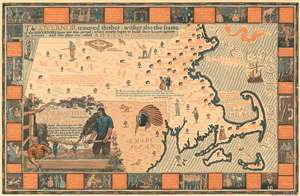
The House Beautiful Map of Old Massachusetts Houses showing their location, type, and other information.
sold
- Digital Map Information
- Suitable for large format printing
- File Size: 31.18 MB
- File Type: ZIP / TIFF
- ICC color profile embedded
- Delivered instantly via download link
Created to celebrate the tercentenary of the Massachusetts Bay Colony in 1930, this Raymond Lufkin pictorial map of Massachusetts highlights historic homes then still standing in Massachusetts. Dozens of houses are marked by icons and identified by the famous occupant's name, among them Paul Revere, John Adams, and Henry Wadsworth Longfellow. Today, many of these houses are national historic sites and museums. A decorative title cartouche adorns the lower left corner and features elements of construction. A pictorial border surrounds the central map and includes vignettes of historic events in the history of Massachusetts. (more details)