
Miller and Company Lithography (sold)

Miller and Company Lithographers (fl. 1830 - 1860) were an American commercial lithographer active in New York City in the mid 19th century. Their work focused mainly on the production short-run real estate maps, particularly in the 1830s, during which time they shared a 15 Broad Street, NY address with prominent real estate auctioneers Franklin and Jenkins. By 1845, 'Miller's Lithography' had its own address at 140 Pearl Street, and were producing maps to accompany governmental reports as well.
The Heart of Williamsburg, Up For Auction!
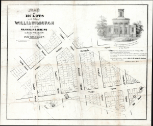
Map of 197 Lots in the Village of Williamsburgh to be sold by Franklin and Jenkins on Friday 8th July 1836 at 12 o'clock at theif Sales Room 15 Broad St. Miller and co Lith 15 Broad St. NY.
sold
- Digital Map Information
- Suitable for large format printing
- Full resolution TIFF file
- ICC color profile embedded
- Delivered instantly via download link
An extremely rare example of this real estate broadsheet map, printed by Miller and Co. on behalf of real estate auctioneers Franklin and Jenkins, to promote a July 1836 auction of lots near the future intersection of Union Street and Grand Street: this map presents one of the densest clusters of fashionable food, wine and nightlife in Williamsburg, capturing it at the moment in which the rural lands of Williamsburgh were just beginning to be transformed into a planned village. (Note that the name of the village and town of Williamsburgh was spelled this way. When it became a city in 1852, they dispensed with the h). The map is among the earliest appearances of the streets as laid out by John S. Stoddard, which would form the framework of Williamsburg and Brooklyn even today. Although Stoddard's surveys would not be confirmed by the New York State Legislature until 1839, they were the surveys of record for the 1835 Acts expanding Williamsburgh's borders (inclusive of the area on this map). Moreover, the real estate market made immediate use of them in maps such as this. It is also the earliest known map to detail the lands, formerly belonging to Bushwick, that had been annexed by Williamsburgh in 1835. (more details)