
Minneapolis Tribune (sold)

The Minneapolis Tribune (1867 - present) was founded by Colonel William S. King, William D. Washburn, and Dorilus Morrison and the first issue was published on May 25, 1867. In 1941, the Cowles family of Des Moines, Iowa bought the Tribune and merged it with their other holdings in Minneapolis, giving the Cowles family ownership of all the city's major newspapers. The Tribune became the city's morning newspaper, and the Star-Journal was the evening newspaper. The two published a joint Sunday edition. The newspaper is still published today, under the name Star Tribune.
Printed a week after the Japanese invasion of Luzon.
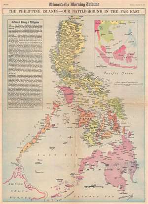
The Philippine Islands - Our Battleground in the Far East.
sold
- Digital Map Information
- Suitable for large format printing
- File Size: 10.18 MB
- File Type: ZIP / TIFF
- ICC color profile embedded
- Delivered instantly via download link
This is a Thursday, December 18, 1941, W. H. Wisner and Minneapolis Morning Tribune map of the Philippines. Printed eight days after the first Japanese landing on Luzon, this map depicts the Philippine Archipelago from Babuyan Channel to the Sulu Archipelago and ... (more details)
The world as it was at the outset of American combat operations during World War II.
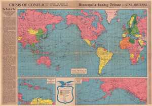
Crisis of Conflict Involves the Destiny of All Nations of the Earth.
sold
- Digital Map Information
- Suitable for large format printing
- File Size: 18.94 MB
- File Type: ZIP / TIFF
- ICC color profile embedded
- Delivered instantly via download link
This is a 1942 Minneapolis Sunday Tribune and Star Journal map of the world at the outset of American involvement in World War II. With North America at center, the map depicts the world from Central Asia across the Pacific to the Americas and then across the ... (more details)
Propaganda map emphasizing the importance of Alaska in the fight against Japan.
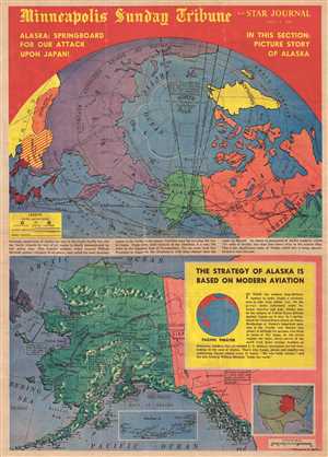
Alaska: Springboard for Our Attack Upon Japan!
sold
- Digital Map Information
- Suitable for large format printing
- File Size: 10.83 MB
- File Type: ZIP / TIFF
- ICC color profile embedded
- Delivered instantly via download link
This is a Warner S. Nelson and Minneapolis Sunday Tribune and Star Journal front page with two maps printed on it from July 5, 1942. The top map depicts a polar map of the North Pole, illustrating Asia and North America, labeling the U.S.S.R., Mongolia, ... (more details)
Published two days before the Allies resumed their offensive to liberate North Africa.
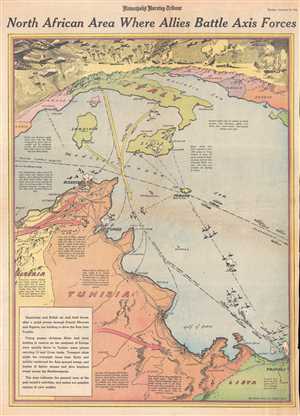
North African Area Where Allies Battle Axis Forces.
sold
- Digital Map Information
- Suitable for large format printing
- File Size: 10.14 MB
- File Type: ZIP / TIFF
- ICC color profile embedded
- Delivered instantly via download link
This is a Tuesday, December 22, 1942 Charles Hamilton Owens and Minneapolis Morning Tribune pictorial map of Tunisia and the Mediterranean Sea. The map depicts the region from southern Europe, including France, Italy, and the Balkans to Tunisia, ... (more details)
Illustrates the final stages of Allied victory in North Africa against Erwin Rommel and the Afrika Korps.
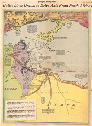
Battle Lines Drawn to Drive Axis From North Africa.
sold
- Digital Map Information
- Suitable for large format printing
- File Size: 10.36 MB
- File Type: ZIP / TIFF
- ICC color profile embedded
- Delivered instantly via download link
This is a February 18, 1943 Minneapolis Morning Tribune pictorial map of the final stages of the Allied campaign against Nazi Field Marshal Erwin Rommel and the Afrika Korps in North Africa. The map depicts the region from Algeria to Libya and ... (more details)
Five presumed options for the Allied invasion of continental Europe - where would they decide to land troops?
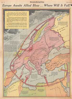
Europe Awaits Allied Blow…Where Will It Fall?
sold
- Digital Map Information
- Suitable for large format printing
- File Size: 11.66 MB
- File Type: ZIP / TIFF
- ICC color profile embedded
- Delivered instantly via download link
This is a Friday, June 4, 1943 Minneapolis Morning Tribune map of Europe preparing for the presumed upcoming Allied invasion. The map depicts the continent from the Atlantic Ocean to the Eastern Front between the Russians and the Germans ... (more details)
Speculates on a possible German invasion of Sweden and Finland in the summer of 1943.
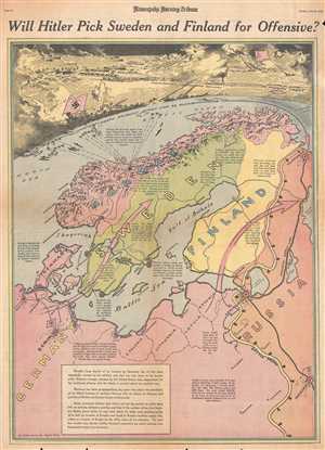
Will Hitler Pick Sweden and Finland for Offensive?
sold
- Digital Map Information
- Suitable for large format printing
- File Size: 11.93 MB
- File Type: ZIP / TIFF
- ICC color profile embedded
- Delivered instantly via download link
This is a Friday, June 25, 1943 Charles Hamilton Owens and Minneapolis Morning Tribune map of Scandinavia. The map depicts the region from the North Sea to Russia and from the Arctic Ocean to eastern Europe. By late June 1943, the ... (more details)
Two months before the Allied victory in North Africa, thoughts of invading Europe are still on everyone's mind.
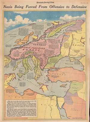
Nazis Being Forced From Offensive to Defensive.
sold
- Digital Map Information
- Suitable for large format printing
- File Size: 11.01 MB
- File Type: ZIP / TIFF
- ICC color profile embedded
- Delivered instantly via download link
This is a Friday, March 19, 1943 Charles Hamilton Owens and Minneapolis Morning Tribune map of 'Fortress Europe'. The map depicts the region from Spain and Algeria to Scandinavia, Russia, Turkey, and the Middle East and from the ... (more details)
The summer supply route between the United States and Russia through the Arctic Circle.
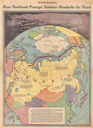
Russ Northeast Passage Summer Headache for Nazis.
sold
- Digital Map Information
- Suitable for large format printing
- File Size: 11.35 MB
- File Type: ZIP / TIFF
- ICC color profile embedded
- Delivered instantly via download link
This is a Friday, May 28, 1943 Charles Hamilton Owens and Minneapolis Morning Tribune pictorial map of Asia illustrating the Northeast Passage. The map depicts the Earth from a polar perspective, with the North Pole at the ... (more details)
Details the presumed Allied invasion of the Balkans - printed one day before the actual invasion of Sicily.
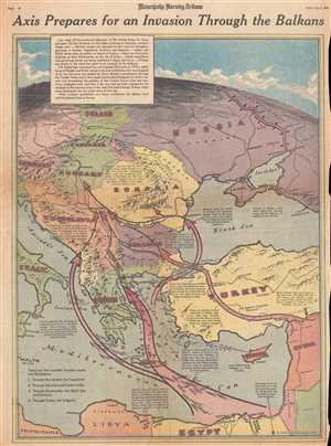
Axis Prepares for an Invasion Through the Balkans.
sold
- Digital Map Information
- Suitable for large format printing
- File Size: 14.08 MB
- File Type: ZIP / TIFF
- ICC color profile embedded
- Delivered instantly via download link
This is a Friday, July 9, 1943 Charles Hamilton Owens and Minneapolis Morning Tribune map of the Balkans and Eastern Europe. The map depicts the region from Italy, Malta, and Libya to Russia, Turkey, and the Middle East ... (more details)
Depicts the Mediterranean islands that were critical to supplying Axis troops in North Africa.
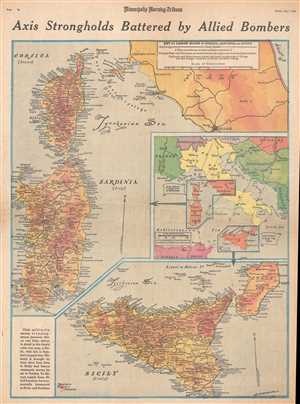
Axis Strongholds Battered by Allied Bombers.
sold
- Digital Map Information
- Suitable for large format printing
- File Size: 11.8 MB
- File Type: ZIP / TIFF
- ICC color profile embedded
- Delivered instantly via download link
This is a Friday, May 7, 1943 William H. Wisner and Minneapolis Morning Tribune map of Italy, Corsica, Sardinia, and Sicily. The map depicts all three islands (Corsica, Sardinia, and Sicily) in full and depicts Italy ... (more details)
Provides an incredible visual summary of combat on the Eastern Front through the beginning of May 1943.
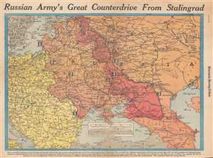
Russian Army's Great Counterdrive from Stalingrad.
sold
- Digital Map Information
- Suitable for large format printing
- File Size: 11.97 MB
- File Type: ZIP / TIFF
- ICC color profile embedded
- Delivered instantly via download link
This is a Wednesday, March 3, 1943 William H. Wisner and Minneapolis Morning Tribune map of the Eastern Front during World War II. The map depicts the region from Copenhagen, Berlin, Prague, and the Adriatic Sea to ... (more details)
Published a week after American forces landed on Leyte and returned to the Philippines.
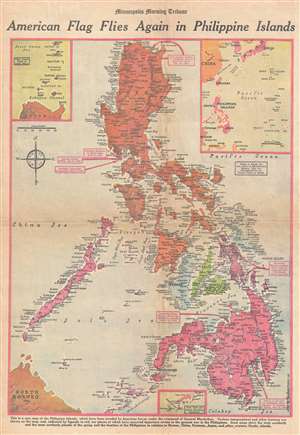
American Flag Flies Again in Philippine Islands.
sold
- Digital Map Information
- Suitable for large format printing
- File Size: 11.51 MB
- File Type: ZIP / TIFF
- ICC color profile embedded
- Delivered instantly via download link
This is a Friday, October 27, 1944 Van Swearingen and Minneapolis Morning Tribune map of the Philippines a week after the American landings on Leyte. The map depicts the region from Luzon to Mindanao and Borneo and ... (more details)