
Nanyang Land Survey Department (sold) (南洋陸地測量司)

Nanyang Land Survey Department (南洋陸地測量司; 1906 - 1928), NLSD for short, was a military survey and mapping office and school created in Nanjing, China, in Guangxu 32 or 1906. The service was attached to the Liangjiang Surveying and Mapping School (两江测绘学堂), attached to the Daxing Palace, which itself was established one year earlier in 1905. The school's aim was to modernize Qing mapping technology, incorporating western printing and surveying technology. The Qing administrators invited Japanese printers and mapmakers to Nanjing, where they taught triangulation, topographic mapping, and cartographic printing. They also facilitated the acquisition of western lithographic presses, and measuring tools. The NLSD remained active until 1928, Minguo 17, when surveying and mapping services were folded into a larger national agency.
AKA: 南洋陸地測量司
One of the first official Chinese city plans to use western survey and printing techniques.
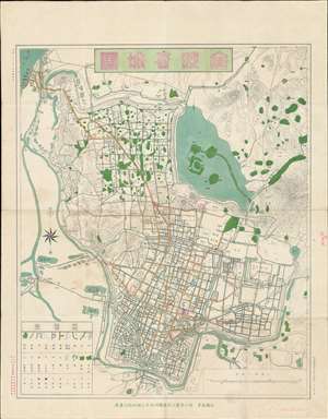
金陵省城圖 / 金陵省城图 / Jinling Provincial City Map.
sold
- Digital Map Information
- Suitable for large format printing
- File Size: 25.08 MB
- File Type: ZIP / TIFF
- ICC color profile embedded
- Delivered instantly via download link
A rare 1907 (Guangxu 33) map of Nanjing (Nanking), China during the late Qing period, issued by the Nanyang Land Survey Department (南洋陸地測量司). This chromolithograph is one of the first Chinese produced and issued official city maps to incorporate western-style surveying methodologies and printing technology. Coverage extends from the Yangtze River (upper left) and the Jiajiang River to Purple Mountain (Zijin Shan; 紫金山) and the Ming Xiaoling Mausoleum (明孝陵). (more details)