
Nihon Meisho Zuesha (sold) (日本名所圖繪)

Nihon Meisho Zuesha (日本名所圖繪; fl. c. 1925 - 1942) was a Japanese publisher of maps, often dealing with cities or travel throughout Japan's growing empire in the 1920s - 1940s, founded by artist and cartographer Koyama Kichizō (小山吉三). They became especially known for bird's-eye views of cities, collaborating with leading artist-cartographers in that genre, such as Yoshida Hatsusaburō (吉田初三郎) and Kaneko Tsunemitsu (金子常光), and developing popular folding sketchbook maps (書簡圖繪) that could be easily mailed and transported.
AKA: 日本名所圖繪
Iconic Bird's-Eye View of Korea.
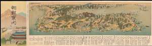
朝鮮安内 / [Guide to Chōsen].
sold
- Digital Map Information
- Suitable for large format printing
- Full resolution TIFF file
- ICC color profile embedded
- Delivered instantly via download link
This is a beautiful 1937 Koyama Kichizō bird's eye view map of the Korean Peninsula, with southern Japan and parts of northeastern China in the background. It was issued by the colonial Government-General (朝鮮總督府) in Keijo (京城 Seoul) for Japanese tourists, businessmen, and residents of Korea. A marginal note indicates that the military has reviewed and approved the mapping of fortifications in several regions. (more details)
Japan's Horrific Victory at Nanjing.
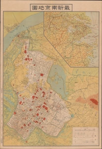
最新南京地圖 / 最新實測南京地圖 / [Latest (Surveyed) Map of Nanjing].
sold
- Digital Map Information
- Suitable for large format printing
- File Size: 32.95 MB
- File Type: ZIP / TIFF
- ICC color profile embedded
- Delivered instantly via download link
A scarce, highly detailed c. 1938 city plan of Nanjing, China, produced by Idemitsu Mamoru soon after the city's capture by Japanese forces in the Second Sino-Japanese War (World War II). This map was issued in the immediate aftermath of the Rape of Nanjing. (more details)
Days after the Rape of Nanjing.
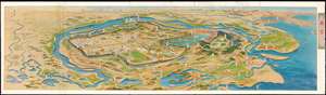
南京 / [Nanjing].
sold
- Digital Map Information
- Suitable for large format printing
- Full resolution TIFF file
- ICC color profile embedded
- Delivered instantly via download link
This is a very rare Koyama Kichizō bird's-eye view map of Nanjing from 1938 (Showa 13), soon after the Rape of Nanjing by Japanese forces in the Second-Sino Japanese War (1937 - 1945). The Yangtze River forms a great arc across the map and, outside of the walled city of Nanjing, major Chinese cities (Shanghai, Xi'an, Chongqing, etc.) are noted in the distance. The idyllic depiction of Nanjing here gives no sense of the intense battle and horrific massacres that had just taken place. (more details)
Qingdao under Japanese occupation, Round II.
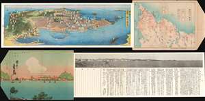
觀光の青島 / [Qingdao Sightseeing].
sold
- Digital Map Information
- Suitable for large format printing
- File Size: 27.72 MB
- File Type: ZIP / TIFF
- ICC color profile embedded
- Delivered instantly via download link
This is a 1938 Koyama Kichizō bird's-eye view map of Qingdao, China, and a fine example of the sketchbook mailer city views that were popular in Japan in the first half of the 20th century. This view was made shortly after the city's capture by Japanese forces in the Second Sino-Japanese War (1937 - 1945), and reflects the complex combination of German, Japanese, and Chinese influences on the city. (more details)