
Pendleton's Lithography (sold)

Pendleton's Lithography (1825 – 1836) was an American lithography firm active in Boston during the early 19th century. The firm was founded by brothers John and William S. Pendleton. Little is known of John, but William apparently moved to Boston from Montreal, Canada with Alexander McKenzie, a copper plate engraver. The two set up business with Abel Bowen from about 1820 to 1825. Around this time John Pendleton entered the picture. He and William purchased some lithographic tools from a Boston merchant named only Thaxter, who apparently acquired them in Europe but did not understand their use. The Pendleton's subsequently became the first lithographers in Boston. Their work was respected for portraiture, landscape prints, music covers, and other illustrations. Among William Pendleton's apprentices are the famous 19th century lithographers Benjamin F. Nutting and Nathaniel Currier (of Currier and Ives). John Pendleton retired from the firm in 1828, but it continued to operate under William. William, in turn, sold the firm to his bookkeeper, Thomas Moore, who changed the name but maintained the same business practices. In 1840, Moore sold out to Benjamin W. Thayer. Pendleton's Lithography was based in three separate locations in Boston: Harvard Place (1825-1826), Graphic Court (1826-ca.1832), and finally Washington Street (ca.1836).
1826 Pendleton issue of John Foster's 1677 map of New England, the first map printed in the English Colonies of North America.
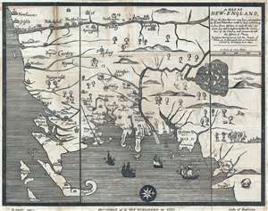
A Map of New-England : being the first that ever was here cut, and done by the best pattern that could be had, which being in some places defective, it made the other less exact: Yet doth it sufficiently show the scituation of the country and conveniently well the distances of places : The figures that are joyned with the names of places are to distinguish such as have been assaulted by the Indians from others.
sold
- Digital Map Information
- Suitable for large format printing
- DPI: 300
- File Size: 24.45 MB
- File Type: ZIP / TIFF
- ICC color profile embedded
- Delivered instantly via download link
This is the Moses Swett 1826 edition of John Foster's 1677 map of New England, the first map printed in America. The map, here as an early 19th century lithograph, was originally printed as a woodcut on single plate. Oriented to the West, the map covers the ... (more details)