
Querenet de la Combe, Guillaume (sold)

Guillaume Querenet de la Combe (1731-1788) was a French officer, engineer and member of the Society of the Cincinnati. He was second in command of the French Engineers under Rochambeau, fought at the Siege of Yorktown, and produced at least one manuscript plan of that battle, which survives in the Rochambeau collection of the Library of Congress.
Plan of the Battle of Yorktown drawn from a French eye-witness account.
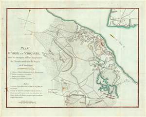
Plan D'York en Virginie avec les attaques et les Campemens de l'Armee combinee de France et d'Amerique. [Battle of Yorktown]
sold
- Digital Map Information
- Suitable for large format printing
- DPI: 600
- File Size: 11.9 MB
- File Type: ZIP / TIFF
- ICC color profile embedded
- Delivered instantly via download link
An important 1787 American Revolutionary War map illustrating the Battle of Yorktown, the last major conflict of the war. The map centers on the battleground just south of Yorktown on the shores of the York River. Gloucester is apparent just across the river. Finely engraved detail is exhibited throughout with fields, swamps, roads, and houses noted. The map was most likely drawn by Querenet de la Combe, a French officer commanding the French Royal Corps of Engineers at the Siege of Yorktown. (more details)