
Redding, George W. (sold)

George W. Redding (fl. c. 1840 – c. 1859) was the founder of Redding and Company, Boston based publishers, book and magazine agents, and quack pharmaceutical agents active in the middle part of the 19th century. Redding's personal and business histories are vague. The firm appears to have been founded around 1841 by George W. Redding and Alexander Williams (August 24, 1818 – January 11, 1900). From their offices at 8 State Street, the firm published their own works, acted as an agent for books and magazines from London and New York, and sold salves and ointments. Advertising for the Redding firm's publications begins appearing around 1841. Under the guidance of Williams, a supreme organizer, the firm introduced magazine distribution throughout New England – at the time a novelty through which they enjoyed significant success. The publishing arm of Redding and Company appears to have dissolved around 1855, but the pharmaceutical arm continued until about 1859. The cure-all Russia Salve was among their more successful products. After 1860 there are conflicting reports. Some suggest that Redding himself died sometime before 1873 and the business passed to other owners. Other sources, including the Boston Directory, suggest that the firm continued to operate as late as the 1880s.
Rare early railroad map of New England.
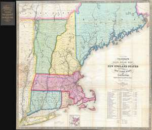
Williams' Telegraph and Rail Road Map of the New England States Eastern Portion of New York State and Canada.
sold
- Digital Map Information
- Suitable for large format printing
- DPI: 300
- File Size: 23.69 MB
- File Type: ZIP / TIFF
- ICC color profile embedded
- Delivered instantly via download link
An extremely rare large format 1852 map of New England published by Alexander Williams and George C. Redding. This was the best railroad map of New England issued following the explosion of railroad construction in the late 1840s. It was prepared to facilitate the first wide scale timely newspaper distribution network in New England. The map covers from the Hudson Valley in Eastern New York to the Maine / New Brunswick border, including all of Massachusetts, Connecticut, Rhode Island, Vermont and New Hampshire, as well as parts of Maine. It provides a detailed breakdown of the rail network as of 1852, including identification of railroad companies, distances, and notes on the construction of the many lines. An inset at bottom center details the Grand Junction Railroad. (more details)