
Rocamora, Marcel M. (sold)

Marcel M. Rocamora (January 28, 1874 - August 26, 1950) was a Canadian guidebook publisher. Rocamora was born in Toronto, Canada, and emigrated to the United States in 1901. He served as president of the Scarborough Motor Guide Company for a number of years and personally led several auto tours organized by the company. He married his wife Edith on December 12, 1903, and the two of them lived in Indianaoplis and Boston and had a summer home in Miami.
The popular Automobile Green Book Map!
Automobile Green Book. The All-in-One Guide.
sold
- Digital Map Information
- Suitable for large format printing
- File Size: 51.78 MB
- File Type: ZIP / TIFF
- ICC color profile embedded
- Delivered instantly via download link
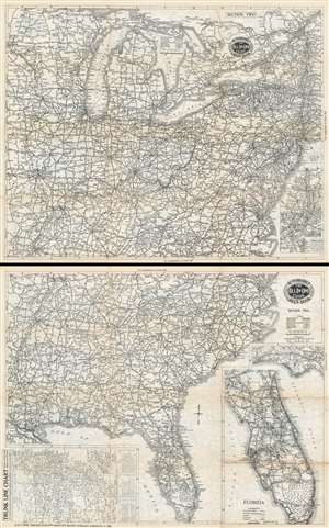
This is a 1933 Scarborough Motor Guide Company road map of the eastern United States published in their celebrated Automobile Green Book. Printed on both sides of the same sheet, the map depicts the United States east of the Mississippi River to Lake Champlain and from southern Lake Superior to New Orleans and along the Gulf Coast to Key Largo. A key printed on the side depicting the southeastern U.S., explains that four different notations are used to differentiate between four different types of roads. The principal trunk lines are marked by thick black lines, while fully improved roads are indicated by thin solid black lines. Dashed black and white lines highlight roads that have only been partially improved, while this while tines mark important connecting roads, which, one imagines, have not been improved at all. Federal and state highway numbers are indicated as well. An inset map situated in the lower right corner of the side detailing the northeastern U.S. focuses on the area surrounding New York City that includes a tip for motorists that are trying to avoid New York City traffic as much as possible. Insets included on the southeastern U.S. side highlight the Florida panhandle between Pensacola and Tallahassee and the whole of peninsular Florida. A third, smaller map, situated in the lower left corner outside the principal map's border, focuses on trunk lines between Montreal and Miami and Eau Claire, Wisconsin and Burlington, Vermont. (more details)