
Rogers, Frank Kimball (sold)

Frank Kimball Rogers (November 28, 1854 - November 23, 1930) was an American draftsman, artist, and viewmaker active in Cape Ann and Boston, Massachusetts. Rogers was born in Gloucester, the son of John Kimball Rogers, a type-founder, and great grandson of Daniel Rogers, one of Gloucester's founding citizens. Rogers is best known as a landscape painter who complete views of Cape Ann, Cape Cod, Gloucester, and Provincetown, among others. He died in Rhode Island and is buried at Oak Grove Cemetery, Essex.
Japanese World War II map of eastern Australia.
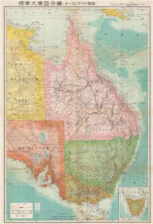
標準大東亞分圖 オーストラリア東部. / Greater East Asia Co-Prosperity Sphere. Eastern Australia.
sold
- Digital Map Information
- Suitable for large format printing
- Full resolution TIFF file
- ICC color profile embedded
- Delivered instantly via download link
This is a stunning 1943 or Showa 18 large format map of eastern Australia. Issued by the Japanese during World War II, this map is part of a series of maps promoting the Japanese imperialist concept of the Greater East Asia Co-Prosperity Sphere. It covers the eastern half of Australia and includes Queensland, New South Wales, Victoria and the eastern parts of South Australia and Northern Territory. An inset of Tasmania is included in the lower right. The map offers superb detail regarding both topographical and political elements. Cities, roads, and air, sea, and land trade routes are illustrated. Shading indicates oceanic depths. While Allied World War II maps of this region are fairly common, it is extremely rare to come across their Japanese counterparts. All text is in Japanese. (more details)