
Routledge, Fred A. (sold)

Fred A. Routledge (September 7, 1871 - April 1936) was an American artist and cartographer best known for his pictorial maps and bird's eye views. Born in Abilene, Kansas, Routledge spent most of his early life in Rockford, Illinois before moving to Portland, Oregon. Routledge worked with the publication West Shore for a short time before finding himself out of work. He found work with the Morning Oregonian beginning in 1895 as the head of its Art Department, a position he reportedly held until 1906. At that time it is clear that hand-drawn illustrations were being replaced by photographic images, but Routledge's work continued to appear in the Oregonian over the ensuing decades. Routledge also worked as artist and cartographer on illustrated books, two of which were published in 1915. Until his death, Routledge produced pictorial maps for many different companies, including Union Pacific, and as promotional material for scenic drives throughout Washington. He married fellow artist Lydia McGowan in 1896.
Traces the route of the Spokane, Portland, and Seattle Railway along the Columbia River.
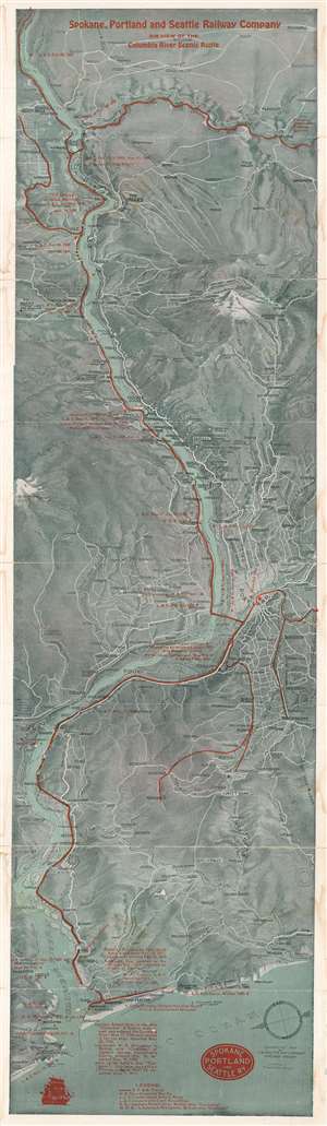
Spokane, Portland, and Seattle Railway Company Air View of the Columbia River Scenic Route.
sold
- Digital Map Information
- Suitable for large format printing
- File Size: 42.57 MB
- File Type: ZIP / TIFF
- ICC color profile embedded
- Delivered instantly via download link
This is a 1916 Fred A. Routledge pictorial bird's eye view of the Columbia River Valley. Overlooking the area from the west, the map depicts the region from Mt. St. Helens and Centerville, Washington to Wapinitia, Oregon and Brighton, Oregon and from Shaniko, Oregon to the Pacific Ocean. Created to promote the Columbia River Scenic Route operated by the Spokane, Portland, and Seattle Railway Company, the railway's routes are highlighted by solid red lines following the course of the Columbia River. Other trunk lines run west from Portland to serve smaller communities, with another heading south from Celilo Falls. Cities and towns across the region are identified, including Portland, The Dalles, and Longview. Important historical events are marked by red overprinting, with particular interest paid to the progress of Lewis and Clark's expedition in the region in 1805 - 1806. Locations of Hudson Bay Company outposts, military forts, and John Jacob Astor's settlement of Astoria are also included. A legend along the bottom border explains the different abbreviations used in these references and a small text gives historical context to Captain Robert Gray of Boston, Lieutenant W.R. Broughton, and John Jacob Astor. (more details)
Scenic railroad along the Columbia River.
Spokane, Portland and Seattle Railway Company Air View of the Columbia River Scenic Route.
sold
- Digital Map Information
- Suitable for large format printing
- Full resolution TIFF file
- ICC color profile embedded
- Delivered instantly via download link
This is a 1916/1928 Fred A. Routledge pictorial bird's-eye view map of the Columbia River Valley published for the Spokane, Portland and Seattle Railway Company. The map was issued to promote the tourism along the Columbia River Scenic Route. (more details)