
Santini, Don Paolo

Paolo Santini (1729 - June 1793) and his brother Francois [Francesco] Santini (fl. 1776 - 1784) were Italian engravers and map publishers based in Venice. The brothers were born in Venice. They are best known for their Atlas Universel dressé sur les meilleures cartes modernes, a grand atlas presenting state-of-the-art French cartography to a Venetian audience. They drew on the cream of 18th Century French cartographers such as Robert de Vaugondy, Jaillot, De L'Isle, and D'Anville. Their atlas was published by the Remondini house in Venice, who purchased the plates and publishing rights from the Santinis in 1781. Paolo was a priest of the Church of Santa Maria Formosa and a professor of architecture in the public schools of Venice. Moreover, he was an ingenious mechanic and invented a large drill used in the Venetian Arsenal for boring cannons, as well as a cutting instrument designed to verify reliably, under any circumstances, the authenticity of licenses issued to merchant captains. With a zigzag cut made in a single movement of the handle, the original document was divided from its matching counterpart. He appears to have been the primary engraver of the two brothers as well. In addition to maps, he also illustrated and engraved architectural plates. He died in Belluno in June 1793, having traveled there to attend the wedding of a close relative. Francesco is believed to have traveled more broadly, including maintaining an office in Paris, where he purchased many of the maps that would inform the brothers' work. He is known to have associated with several French cartographers of the late 18th century, including Rigobert Bonne. His offices in Paris were located at Rue St. Justine pres de L'Eglise.
Essential French and Indian War Map, Made Relevant to the Revolution.
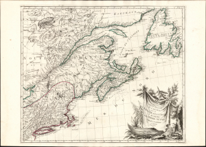
Partie Orientale du Canada avec la Nouvelle Angleterre, l'Acadie, et la Terre-Neuve.
$1,500.00
Acquire
- Digital Map Information
- Suitable for large format printing
- Full resolution TIFF file
- ICC color profile embedded
- Delivered instantly via download link
This is Paolo and Francesco Santini's 1776 map of eastern Canada, New England, Acadia, and Newfoundland. Produced to satisfy European interest in the events of the American Revolutionary War (1775 - 1783), it drew on the best French mapping of the region produced during the French and Indian War (1754 - 1763). (more details)
Speculating on a Northwest Passage and a Sea of the West.
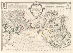
Carte Des Nouvelles Decouvertes au Nord de la Mer de Sud, tant a l'Est de la Syberie et du Kamtchatka, qu'a L'Ouest de la Nouvelle France.
$1,700.00
Acquire
- Digital Map Information
- Suitable for large format printing
- DPI: 600
- File Size: 29.72 MB
- File Type: ZIP / TIFF
- ICC color profile embedded
- Delivered instantly via download link
The 1776 Francois Santini Venice edition of Joseph Nicolas De l'Isle's extraordinary 1752 map of North America, Siberia, the Arctic, and the North Pacific. The map is a study in contrasts, setting J. N. De L'Isle's accurate mapping of the Asian northeast based on data absconded from the Russian 'Academy of Sciences', against J. N. Buache's speculations on the feasibility of a Northwest Passage. Among other points, this map is significant for reviving the 'Sea of the West' hypothesis, and must be considered one of the most influential maps of the region issued in the mid-18th century. (more details)
Fascinating map the divides the world into terrestrial and maritime hemispheres and argues for a Paris Prime Meridian.
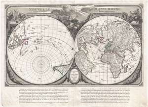
Nouvelle Mappe Monde dedièe au progrès de nos connoissances.
$1,800.00
Acquire
- Digital Map Information
- Suitable for large format printing
- DPI: 300
- File Size: 15.38 MB
- File Type: ZIP / TIFF
- ICC color profile embedded
- Delivered instantly via download link
An impressive and unusual 1784 map of the world on dual polar projections by François Santini and the Remondini family. This map was originally drawn by Nicholas-Antoine Boulanger and published in Paris by Chez R. J. Julien in 1753. Boulanger divides the world ... (more details)
Refining the Map of America's Northwest Coast.
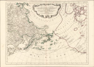
Nouvelle Carte des Decouvertes Faites par des Vaisseaux Russiens aux Cotes Inconnues de l'Amerique Septentrionale avec les Pais Adiacents. Dressée sur des memoires authentiques de ceux Qui ont assisté a ces decouverts, et sur d'autres Connoissances.
$1,000.00
Acquire
- Digital Map Information
- Suitable for large format printing
- Full resolution TIFF file
- ICC color profile embedded
- Delivered instantly via download link
This is Paolo Santini's pirated 1784 edition of Jacob von Staehlin's update to Gerhard Muller's map of the Pacific Northwest, Alaska, the Arctic, and Siberia. It illustrated the findings of Vitus Bering's Great Northern Expedition and subsequent Russian explorations, and was among the most accurate maps of the northwest coast of America available outside Russia before the voyages of Cook, La Pérouse, and Vancouver. (more details)