
Sherburne, Beulah Locke (sold)

Beulah Locke Sherburne (1887 - 1942) was an American artist from Massachusetts. Little is known about her life other than that she married Warren Sherburne on October 3, 1912 with whom she had two children.
Highlights historic houses and sailing ships.
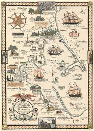
Map of Plymouth, Kingston, and Duxbury shewing landmarks of ye olde dayes.
sold
- Digital Map Information
- Suitable for large format printing
- File Size: 49.59 MB
- File Type: ZIP / TIFF
- ICC color profile embedded
- Delivered instantly via download link
Rare and brimming with charm, this is a 1929 Beulah Locke Sherburne pictorial map of Plymouth, Kingston, and Duxbury, Massachusetts. The map depicts the region from the Mayor John Bradford House to Massachusetts Bay and from Green Harbor to Chintonville and Warren Cove. Wonderfully illustrated, historic sites from Marshfield south along the bay to Chiltonville are presented in profile, with the John Howland House, William Harlow House, William Creowe House, and King Caesar House among said sites. The first parish in Duxbury is shown next to the town hall and the Partridge Academy. Plymouth Rock in Plymouth is identified as is the Forefathers Monument. Historic sailing ships, the Mattakeesett, Pinkie, and Mayflower, ply the waters of Duxbury Bay, Kingston Bay, and Plymouth Bay, while the Hope, the largest merchant ship in New England as of 1841, has set sail in Massachusetts Bay. A whale is also included in Plymouth Bay, with a caption noting that a whale upset a whaleboat in the general vicinity of the vignette in 1712. The whole is surrounded by a rope border that features illustrations of colonial life and the seals of Duxbury, Kingston, and Plymouth. (more details)