This item has been sold, but you can get on the Waitlist to be notified if another example becomes available.
1863 J. C. Smith Wall Map of the United States highlighting the Civil War
UnitedStatesCivilWar-smith-1863$3,750.00

Title
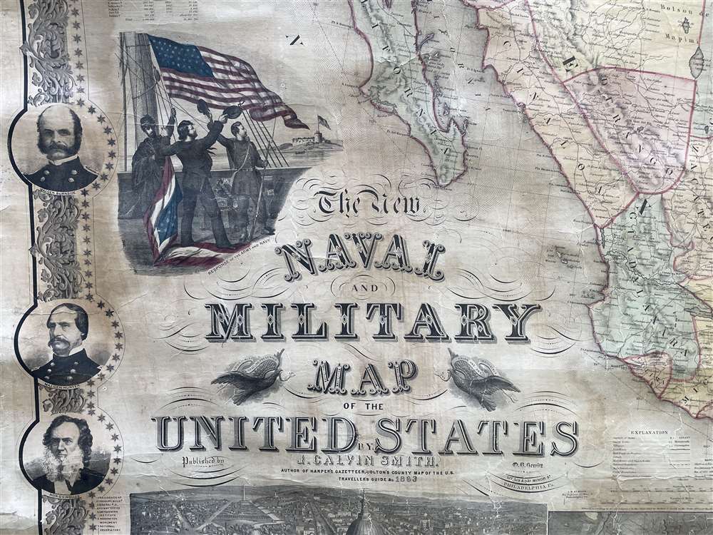
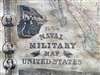
The New Naval and Military Map of the United States.
1863 (dated) 68.75 x 67 in (174.625 x 170.18 cm) 1 : 3275000
1863 (dated) 68.75 x 67 in (174.625 x 170.18 cm) 1 : 3275000
Description
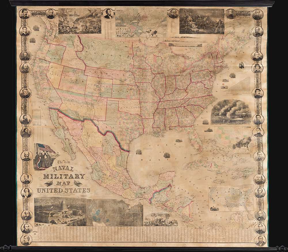
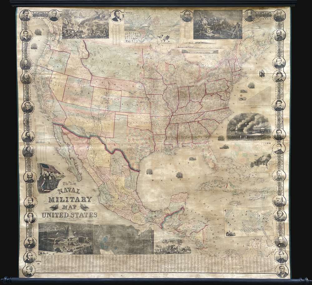
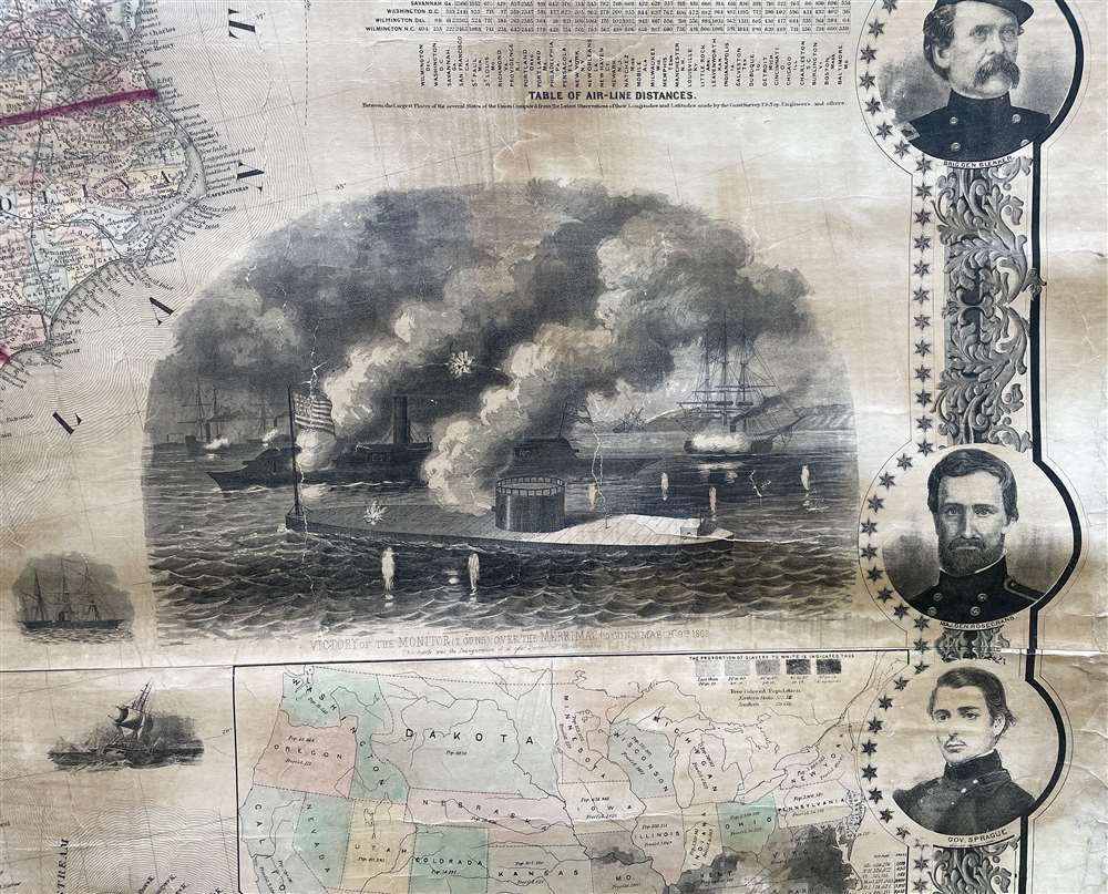
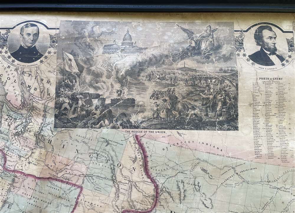
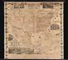
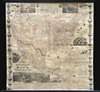
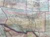
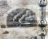
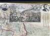
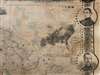
This is a rare 1863 wall map of the United States at the height of the American Civil War (1861 - 1865). The map was issued by John Calvin Smith and Robert Persall Smith during the Civil War to capitalize on general interest in the war among the northern elite. At roughly 70 inches square, this enormous and lavishly produced map covers all of the United States and Mexico. The early state and territory configuration includes the ephemeral Confederate State of Arizona. It is surrounded by images of Union officers and politicians - including Lincoln, Fremont, Wilkes, and Scott. Curiously, these do not include General Grant, as the map's publication in early January of 1863 predates his assumption of overall command on January 29, 1863. The map features multiple vignette scenes including the victory of the Monitor over the Merrimac, the allegorical 'Rescue of the Union', an illustration of 'Camp Life', the Capitol building in Washington, and an overview of the 'Birth of the Union' at Bunker Hill. Of note, the Pacific Telegraph Route is noted running parallel to the Pony Express Route, which is also illustrated.
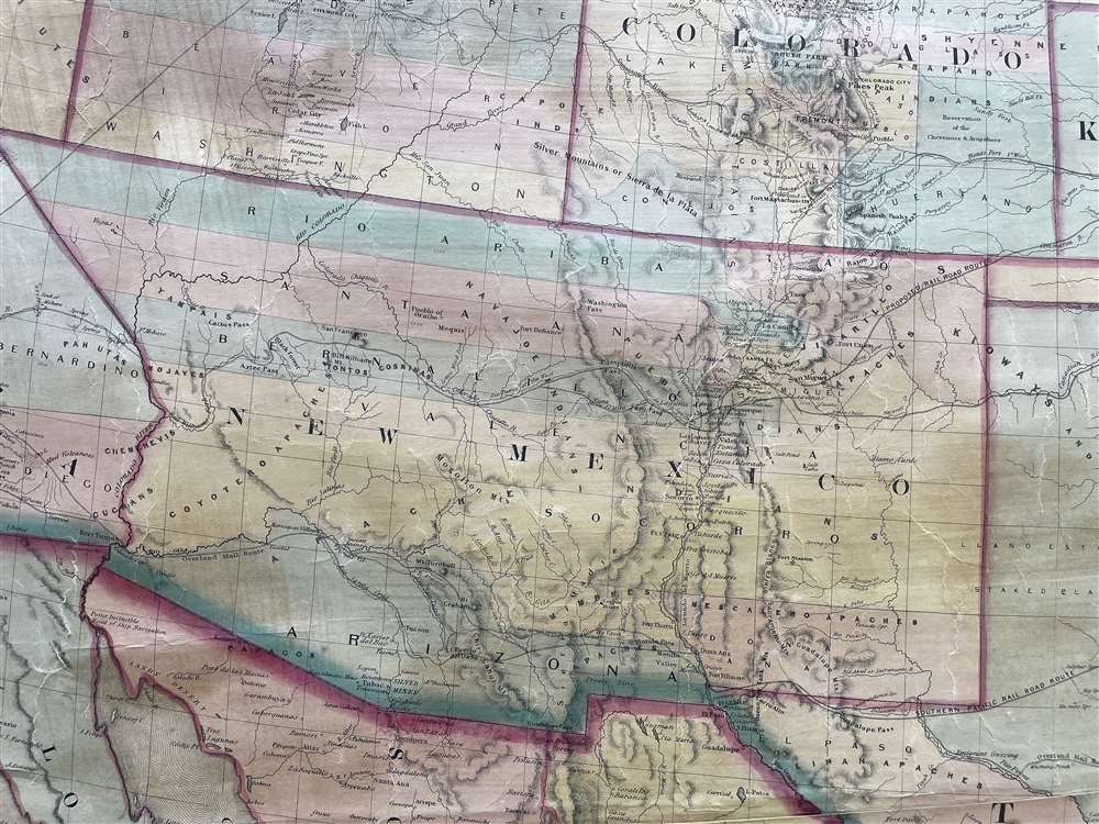
At the beginning of the Civil War, support for the Confederacy ran high in the southern parts of the New Mexico Territory. Local concerns drove this sentiment, including a belief that the war would lead to an insufficient number of Federal troops to protect the citizens from the Apache, while others simply felt neglected by the government in Washington. Also, the Butterfield Overland Mail Route (an overland mail and stagecoach route from Memphis and St. Louis to San Francisco) was closed in 1861, depriving the people of Arizona of their connection to California and the East Coast.
All of these factors led to the people of the southern New Mexico Territory, or the Arizona Territory, to formally call for secession, and a convention adopted a secession ordinance on March 16, 1861, with a subsequent ordinance ratified on March 28, establishing the provisional territorial government of the Confederate 'Territory of Arizona'. The Confederate Arizona Territory was officially proclaimed on August 1, 1861 following Lieutenant-Colonel J. R. Baylor's victory over Union forces in the First Battle of Mesilla, and the territory was officially recognized by the government of the Confederacy on February 14, 1862. However, by July 1862, Union forces from California, known as the 'California Column' were marching on the territorial capital of Mesilla. Sent to protect California from a possible Confederate incursion, the 'California Column' drove Confederate forces out of the city, allowing them to retreat to Franklin, Texas. The territorial government fled as well and spent the rest of the war in 'exile'. First, they retreated to Franklin, then, after Confederate forces abandoned Franklin and all of West Texas, to San Antonio, where the 'government-in-exile' spent the rest of the war. Confederate units from Arizona would fought throughout the war, and the delegate from Arizona attended both the First and Second Confederate Congresses.
A Most Interesting Chart
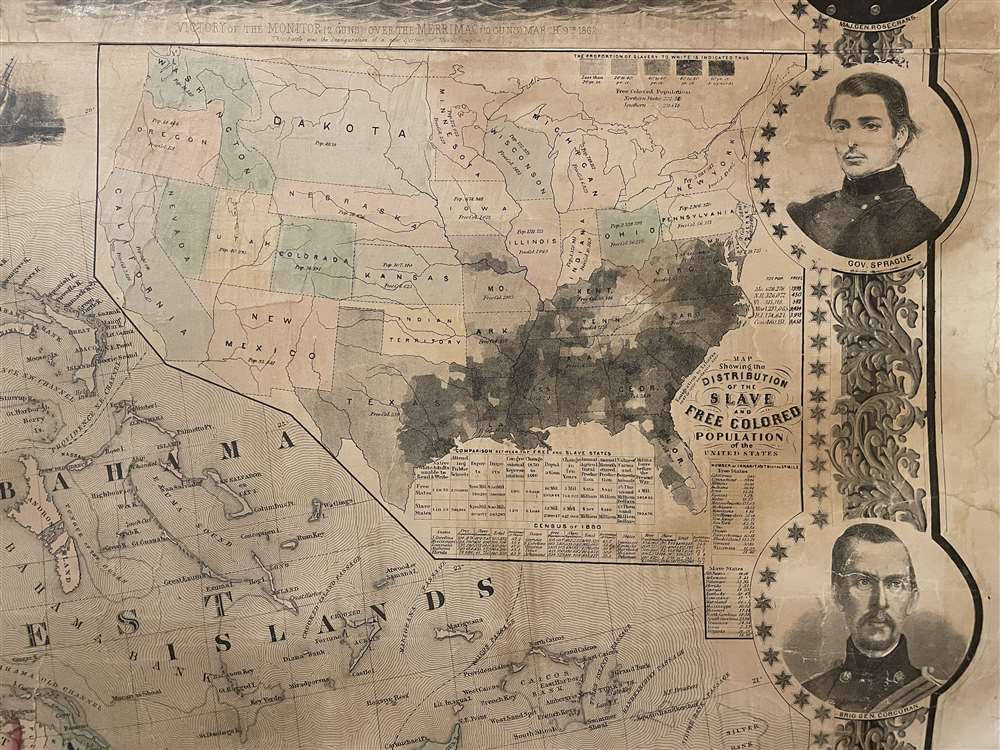
Below the vignette illustrating the Monitor and Merrimac there is an intriguing chart and 'Map Showing the Distribution of the Salve and Free Colored Population of the United States.' Black shading highlighted the presence of slaves - primarily along major river arteries, and along the coast, where cotton production was most prominent. The 'free colored' population of each state is noted, with Mississippi being shockingly low at just 731 free people of color, set against a slave population of nearly 440,000. The statistical table is rather damning to the 'Slave States' which, while strong in exports (cotton), lag severely in every other sector, including education, manufacturing, imports, agriculture, population, and military might - 1 in every 13 people in the slave states were illiterate, as opposed to 1 in 55 in free states.Confederate Arizona
Confederate Arizona was a territory claimed by the Confederate States of America from 1861 until 1865. The idea for an Arizona Territory appears as early as 1856, when the government of the Territory of New Mexico began to express concerns about being able to effectively govern the southern part of the territory, as it was separated from Santa Fe by the Jornada del Muerto, a particularly unforgiving stretch of desert. The New Mexico territorial legislature acted on these concerns in February 1858, approving a resolution in favor of creating an Arizona Territory, with a north-south border to be defined along the 32nd meridian (from Washington). Impatiently waiting for Congress to approve the creation of the new territory, 31 delegates met at a convention in Tucson in April 1860 and drafted a constitution for the 'Territory of Arizona', which was to be organized out of the New Mexico Territory below 34th parallel. The convention even elected a territorial governor and a delegate to Congress. Congress, however, was reluctant to act. Anti-slavery Representatives knew that the proposed territory was located below the line of demarcation set forth by the Missouri Compromise for the creation of new slave and free states, and they were not inclined to create yet another slave state. Thus, Congress never ratified the proceedings of the Tucson convention, and the Provisional Territory was never considered a legal entity.At the beginning of the Civil War, support for the Confederacy ran high in the southern parts of the New Mexico Territory. Local concerns drove this sentiment, including a belief that the war would lead to an insufficient number of Federal troops to protect the citizens from the Apache, while others simply felt neglected by the government in Washington. Also, the Butterfield Overland Mail Route (an overland mail and stagecoach route from Memphis and St. Louis to San Francisco) was closed in 1861, depriving the people of Arizona of their connection to California and the East Coast.
All of these factors led to the people of the southern New Mexico Territory, or the Arizona Territory, to formally call for secession, and a convention adopted a secession ordinance on March 16, 1861, with a subsequent ordinance ratified on March 28, establishing the provisional territorial government of the Confederate 'Territory of Arizona'. The Confederate Arizona Territory was officially proclaimed on August 1, 1861 following Lieutenant-Colonel J. R. Baylor's victory over Union forces in the First Battle of Mesilla, and the territory was officially recognized by the government of the Confederacy on February 14, 1862. However, by July 1862, Union forces from California, known as the 'California Column' were marching on the territorial capital of Mesilla. Sent to protect California from a possible Confederate incursion, the 'California Column' drove Confederate forces out of the city, allowing them to retreat to Franklin, Texas. The territorial government fled as well and spent the rest of the war in 'exile'. First, they retreated to Franklin, then, after Confederate forces abandoned Franklin and all of West Texas, to San Antonio, where the 'government-in-exile' spent the rest of the war. Confederate units from Arizona would fought throughout the war, and the delegate from Arizona attended both the First and Second Confederate Congresses.
Publication History and Census
This map was first published in 1862. The copyright is registered to Robert Pearsall Smith, but the map is more prominently attributed to John Calvin Smith. It was engraved by John Atwood. There are two editions, 1862 and 1863, the present example being the 1863 second edition. The primary difference between editions, beyond the date, is the swapping of some of the generals and other political figures around the border to those who distinguished themselves in 1862. All editions are rare. We note examples at the Library of Congress and in a few private collections.CartographerS
John Calvin Smith (1809 – June 11, 1890) was an American surveyor and geographer active in New York during the middle part of the 19th century. He was a charter member of the American Geographical and Statistical Society (American Geographical Society). He worked with other important New York cartographers including John Disturnell, George Sherman, and Samuel Stiles, with whom he often published under the Stiles, Sherman & Smith imprint. Stiles may have introduced Smith to J. H. Colton, who acquired many of his map plates in 1853. Most of Smith's maps focus on New York counties, but he also issued maps of the United States, Illinois, Texas, and the California gold fields. Despite being an important and prolific cartographer, much of his personal life and history are shrouded in mystery. More by this mapmaker...
John M. Atwood (1817 - October 12, 1884) was an American engraver based in Philadelphia and New York City during the middle part of the 19th century. Atwood was born in Georgetown, near Washington D.C. Little is known of Atwood's life but most of his work was completed in conjunction with the publishing firms of Horace Thayer and J. H. Colton. A review of Atwood's work suggests that he was a highly accomplished, stylistically distinct, and detail oriented engraver. Colton seems to have turned to Atwood to engrave some of his most important as well as decorative maps. His most influential map is most likely the 1856 De Cordova pocket map of Texas, however, he also engraved the Colton's well known and highly decorative Thirty Three Miles Around New York and Colton's important 1849 Map of the United States. Learn More...
Robert Pearsall Smith (February 1, 1827 - April 17, 1898) was an American map maker active in Philadelphia from the middle to late 19th century. Smith was born to a Quaker family in Philadelphia, all librarians and publishers. Robert Pearsall originally ran a law bookstore at 19 James Street, Philadelphia. It was not until 1846 that Smith began producing maps in collaboration with this father, John Jay Smith, and brother, Lloyd P. Smith. One year earlier, in 1845, John Jay, then librarian at the Library Company of Philadelphia and Loganian Library, acquired the American rights to the anastatic process of transfer lithography. In February of 1846 he and his two sons founded the Anastatic Office, a printing concern based on the anastatic process located at 317 Market Street, Philadelphia. The Anastatic Office produced numerous copies and reissues of historic documents and maps from the Library Company's collection before being dissolved in 1847. In the same year Robert Pearsall opened a printing establishment under his own name at 144 Chestnut Street. In 1858, he joined forced with the Swiss-American engraver Frederick Bourquin (1808 - 1897) under the imprint 'F. Bourquin and Company' (602 Chestnut Street). Smith retired suddenly and inexplicably from the printing business around 1865. Smith was also deeply religious, a lay leader in the Holiness Movement in the United States and the Higher Life Movement in Great Britain. Smith and his wife, Hannah Tatum Whitall, first crossed the Atlantic to preach in England, Germany and Switzerland in 1873. They returned in 1875, preaching in Brighton, where Smith supposedly had an affair with an American writer. In, 1888, his entire family moved to England. Learn More...
Condition
Very good. Full professional restoration. Some crackling, discoloration. Fresh linen backing.
References
Library of Congress, Civil War Maps (2nd ed.), 32.5.