
Streit, Friedrich Wilhelm (sold)

Friedrich Wilhelm Streit (January 29, 1772 - June 12, 1839) was a Prussian military officer, engineer, mathematician, and cartographer. Streit began his career as an artillery officer in the Prussian military, where he honed his mathematical and cartographic skills. After leaving military service at the rank of major, he became a member of the Akademie gemeinnütziger Wissenschaften zu Erfurt and Gesellschaft für Erdkunde, one of the leading Prussian geographical bodies of the day. From 1807 to 1817 he was director of the map department of the Geographisches Institut Weimar. Over the same period, he oversaw the 'Topographisch-militairische Charte von Teutschland,' an ambitious project to survey the entirety of Central Europe on a consistent medium scale (1:180000), resulting in over 200 maps and supplements. He also published textbooks on mathematics and an English-German dictionary.
Die grosse Republik Texas.
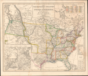
Die Vereinigten Staaten von Nord-Amerika.
sold
- Digital Map Information
- Suitable for large format printing
- Full resolution TIFF file
- ICC color profile embedded
- Delivered instantly via download link
A scarce 1848 German-language map of the United States by Friedrich Wilhelm Streit, published by J.C. Hinrichs'sche Buchhandlung. It is notable, among other features, for its illustration of the Republic of Texas and for its depiction of ephemeral territorial borders in the central United States. (more details)