
Toms, William Henry (sold)

William Henry Toms (1701 - 1765) was an English engraver, print seller, publisher and stationer active in London during the early to middle 18h century. The son of Peter Toms, Henry apprenticed under John Harris from 1716. He was engraving independently from at least 1726 and his imprint appears on portraits, books plates, landscapes, maps and architectural prints. His name appears on the great Popple map of North America as well as on important maps by Lempriere, Seale, Boulton, Moll, and others. He was imprisoned for debt in 1761. His son, Peter Toms II (1726 - 1777) became a well known painter. His apprentices included the engraver and publisher John Boydell (January, 19 1720 - December 12, 1804). He lived on Masham Street, London. His work also appears as 'Henry William Toms', 'W. H. Toms', and 'Thoms'.
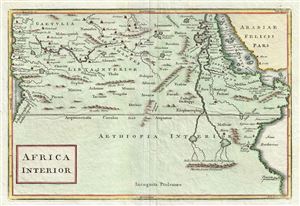
Africa Interior.
sold
- Digital Map Information
- Suitable for large format printing
- Full resolution TIFF file
- ICC color profile embedded
- Delivered instantly via download link
A very curious map of central Africa dating to approximately 1730 by Henry H. Toms. It covers the mid-section of Africa roughly from the Gulf of Guinea and the Atlantic eastward to the Red Sea and the horn. Extends southward as far as modern day Tanzania. The ... (more details)
Earliest Acquirable View of Charleston, South Carolina.
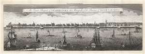
An Exact Prospect of Charlestown, the Metropolis of the Province of South Carolina.
sold
- Digital Map Information
- Suitable for large format printing
- Full resolution TIFF file
- ICC color profile embedded
- Delivered instantly via download link
This is the most important early view of Charleston, South Carolina. This view of Charleston was published in 1779 by the London Magazine. It is one of the few images available to the collector of the pre-Revolutionary colonial south, capturing the city when it was the fourth largest port in the North American British colonies. It is based on the unobtainable rare view of the same title engraved by William Henry Toms (c. 1700 - 1765) in 1739, in turn based on a watercolor painted from life by American artist Bishop Roberts between 1735 and 1739. (This original watercolor is in the collection of Colonial Williamsburg.) The view shows the waterfront of the city as seen from the opposite bank of the Cooper River. It clearly illustrates the town's shoreline batteries, warehouses, and wharves. Several structures are marked with a letter key: these are the Granville Bastion, the courthouse, the council chamber, the Quaker meeting house, the spire of Saint Philip's Church, the Customs House, and at the far-right Craven's Bastion. The waters of the Cooper are filled with ships, ranging from humble rowboats to British warships - underscoring both Charleston's prosperity and military significance. In the foreground, a group of fishermen wrestle a great fishnet ashore. The beautifully engraved sky above the city is teeming with birds. (more details)