
Traster, Sr., R.C. (sold)

R.C. Traster, Sr. (18xx - 19xx) was an American printer, publisher, map maker, and advertising agent active in Miami during the first half of the twentieth century. Traster arrived in Miami in 1929 as the president of the T-A-D Companhy, which specialized in aerial advertising. He planned to spend the winter there promoting aviation in the city, particularly on behalf of the manufacturer of the Monocoupe. By the mid-1930s, Traster was publishing maps and views of American cities, particularly Miami and by the late 1940s was publishing guidebooks of South Florida.
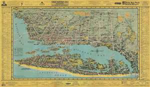
A wartime bird's eye view of Miami promoting tourism in the city.
[Miami. Miami Beach.]
sold
- Digital Map Information
- Suitable for large format printing
- File Size: 41.84 MB
- File Type: ZIP / TIFF
- ICC color profile embedded
- Delivered instantly via download link
This is a 1945 R.C. Traster, Sr. and Carmel Wilson bird's eye view of Miami and Miami Beach, Florida. From high over the Atlantic Ocean, the view overlooks the region from the east, with Biscayne Bay stretching to the left off the sheet. Myriad buildings are illustrated throughout, many of which are labeled as housing private companies, bars, restaurants, and schools, among others. Streets are illustrated and labeled, with major streets colored white such that they are easily located, while neighborhood streets are darker and fade into the landscape. The three causeways connecting the two cities are labeled, as are the islands in Biscayne Bay, including Belle Isle, Palm Island, and Star Island. The whole is framed by advertisements promoting local businesses, shopping centers, realtors, restaurants, hotels, and public transit. Columns on the left and right sides list hotels that are 'open to civilians' and include a grid location to help viewers locate them on the present map. (more details)