
Tupaia (sold)

Tupaia (c. 1725 - December 26, 1770), also known as Tupaea or Tupaya, was a Tahitian navigator, artist, and arioi, or priest, of the war god 'Oro. He was born on the island of Ra'iatea near Ha'amanino Harbour, in the Society Islands. Following in a family tradition he became an ariori priest for the Taputapuatea marae. Tupaia was trained in the fare-'ai-ra'a-'upu, or schools of learning, about the origin of the cosmos, genealogies, the calendar, proverbs and histories. Additionally, his grandfather passed on to him traditional secrets of Tahitian oceanic navigation. When Ra'iatea was invaded by warriors from BoraBora in 1763, he fled to Tahiti where he became a prominent priest. When the English under Captain James arrived in June of 1769, he became fascinated by the strange Europeans. He attached himself to Samuel Wells and alter Joseph Banks. Under the patronage of Banks, but against Cook's better judgment, Tupaia joined the crew of the H. M . S. Endeavour. During his short stint on the Endeavour, he completed several watercolors, helped with navigation, and drew an important map of the Society Islands, the first examples of indigenous Polynesian cartography to make its way to Europe. Nonetheless, Tupaia remained unpopular with Cook, but had his grudging admiration, as described by Joseph Marra, a midshipman on the Endeavour,
Toobia ... was a man of real genius, a priest of the first order, and an excellent artist: he was, however, by no means beloved by the Endeavour's crew, being looked upon as proud and austere, extorting homage, which the sailors who thought themselves degraded by bending to an Indian, were very unwilling to pay, and preferring complaints against them on the most trivial occasions.With Tupaia's help the Endeavour made its way to Australia where they landed at Botany Bay in April of 1770. In November of that same year, the Endeavour landed in Batavia for repairs. There Tupaia contracted either dysentery or malaria from which he died shortly thereafter on December 26, 1770.
Russian edition of Tupaia's Chart - a relic of the first Cook Expedition to the South Pacific and an illustration of advanced Polynesian navigation techniques.
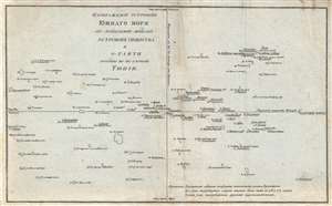
ИЗОБРАЖЕНІЕ ОСТРОВОВЪ ЮЖНАГО МОРЯ ПО ПОКАЗАНИЮ ЖИТЕЛЕЙ ОСТРОВОВЪ ОБЩЕСТВА И O-TAИTИ. / A Chart representing the Isles of the South Sea, according to the notions of the Inhabitants of O'Taheitee and the Neighboring Isles chiefly collected from the accounts of Tupaya.
sold
- Digital Map Information
- Suitable for large format printing
- DPI: 300
- File Size: 3.76 MB
- File Type: ZIP / TIFF
- ICC color profile embedded
- Delivered instantly via download link
A significant discovery of considerable rarity, this is a c. 1777 Russian language version of the Tupaia Chart or map of the Society Islands and Tahiti. The map is based upon the indigenous cartography of Tupaia, a Tahitian navigator who drew this map in 1770 ... (more details)