
Yasuda, Torao
Japan's Careful Observation of the Sino-French War.
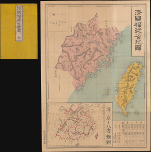
清國福建省地圖 / [Map of the Qing Province of Fujian].
$1,800.00
Acquire
- Digital Map Information
- Suitable for large format printing
- Full resolution TIFF file
- ICC color profile embedded
- Delivered instantly via download link
This is a rare and important 1884 Japanese folding map of Fujian Province, China, including Taiwan, prepared by Yasuda Torao. It was published just eleven days after the French destroyed the Chinese Fujian fleet at Fuzhou, a key event in the Sino-French War (1884 - 1885). Its publication put a detailed regional map in front of Japanese readers as the Sino-French War brought fighting to the Taiwan Strait and the island's geography and the limits of Qing authority had become matters of international strategic interest. Issued a decade after a Japanese military expedition to Taiwan and a decade before Japan seized the island as a colonial possession, the map appeared as Japanese ambitions vis-à-vis China were rapidly growing, upending the traditional hierarchy in East Asia. (more details)