
Yukawa Shunji (sold) (湯川俊次)

Yukawa Shunji (湯川俊次; fl. c. 1928 - 1937) was a Tokyo-based cartographer who made maps of the region around Tokyo, including Mt. Fuji, and the Tokaido.
AKA: 湯川俊次
The Tokaido Road - the artery of empire.
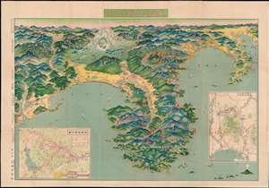
東海道名勝案内圖 / [Guide Map of Famous Sites on the Tokaido].
sold
- Digital Map Information
- Suitable for large format printing
- Full resolution TIFF file
- ICC color profile embedded
- Delivered instantly via download link
An absolutely stunning and rare panoramic view of the Kanto region, Japan, including Mt. Fuji and the Tokaido, originally printed in 1926 (Taisho 15) and reprinted here in a fifth 1928 (Showa 3) edition. The view is somewhat unusual in that it takes the Tokaido itself as the main subject, rather than Tokyo or Mt. Fuji as is more common, although it only includes the eastern half of the road and Mt. Fuji is still the most prominent feature. Yokohama and Tokyo are at top-right. This view also includes two inset maps, one an overhead map of Mt. Fuji and the other a sightseeing map of Hakone. (more details)