
Abbot, Henry Larcom (sold)
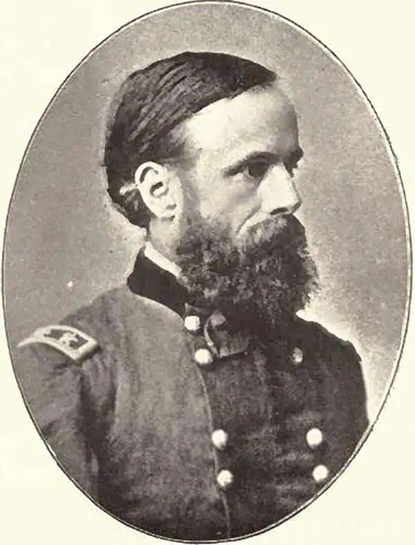
Henry Larcom Abbot (August 13, 1831 - October 1, 1927) was an engineer and career officer in the United States Army. Born in Every, Massachusetts, Abbott graduated second in his class at West Point in 1854. Commissioned as a brevet second lieutenant on July 1, 1854, Abbot had initially wanted to join the Artillery, but a friend convinced him that the Engineers was a better option. By 1855, Abbot had been assigned to Lieutenant Robert Williamson's Pacific Railroad Survey in California and Oregon. Abbot also participated in several studies of the Mississippi River, including a notable study of the river's flow from the confluence with the Ohio River south to the Gulf of Mexico. Abbot was assigned to Brigadier General Irvin McDowell's forces at the outbreak of the American Civil War and was wounded at the First Battle of Bull Run. later, he served as a topographical engineer with the Army of the Potomac during the Peninsula Campaign, where he earned a brevet promotion to major at the siege of Yorktown. After the Peninsula Campaign, Abbot was transferred to command a heavy artillery unit, though that appointment did not last long as he was soon sent to Washington, D.C. to command a brigade defending the capital. In May 1864, Abbot was sent to command the artillery during the siege of Petersburg, and by December he was placed in command of all siege artillery in the Army of the Potomac and the Army of the James. After the war, Abbot remained in the army and served with the Army Corps of Engineers. He was placed in command of an engineer batallion at Willet's Point, New York, where he founded the army's Engineer Engineer School of Application, the first of its kind in the United States. After retiring from the army in 1895, Abbot continued to work as a civil engineer and was even employed as a consultant on the lock system for the Panama Canal.
Definitive moment in the American understanding of rivers.
U.S. Miss. Delta Survey. Plate II. Map of the Alluvial Region of the Mississippi.
sold
- Digital Map Information
- Suitable for large format printing
- File Size: 20.75 MB
- File Type: ZIP / TIFF
- ICC color profile embedded
- Delivered instantly via download link
This is Andrew A. Humphreys and Henry L. Abbot 1861 map of the Mississippi River alluvial region, from Cape Girardeau through New Orleans and into the Gulf of Mexico. Produced on the eve of the American Civil War (1861 - 1865), the map marks a major advancement in the understanding of rivers and their flows, particularly the Mississippi River. (more details)
Definitive moment of the American understanding of Rivers.
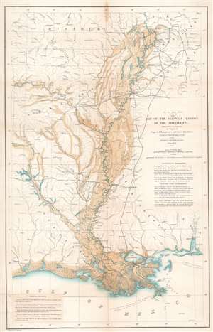
U.S. Miss. Delta Survey. Plate II. Map of the Alluvial Region of the Mississippi.
sold
- Digital Map Information
- Suitable for large format printing
- File Size: 23.97 MB
- File Type: ZIP / TIFF
- ICC color profile embedded
- Delivered instantly via download link
This is an 1861 Andrew A. Humphreys and Henry L. Abbot map of the Mississippi River alluvial region. Depicting from Jonesboro, Illinois, south to the Gulf of Mexico and from Fort Smith, Missouri, east to Clarksville, Tennessee, the region's river network is depicted in detail. Blue hand coloring highlights major rivers, including the Mississippi, Ohio, Arkansas, and Red Rivers, along with numerous lakes. Smaller rivers and creeks are marked by thin black lines. Overflow areas are shaded brown. Railways, such as the Memphis and Little Rock Railroad, the Shreveport and Texas Railroad, and the Cairo and Fulton Railroad, are illustrated and labeled. (more details)
Illustrates the beginning of the Peninsula Campaign during the American Civil War from Fort Monroe to Williamsburg.

Campaign Maps Army of the Potomac Map No. 1 Yorktown to Williamsburg Prepared by Command of Maj. Gen. George B. McClellan, U.S.A.
sold
- Digital Map Information
- Suitable for large format printing
- File Size: 15.76 MB
- File Type: ZIP / TIFF
- ICC color profile embedded
- Delivered instantly via download link
This is an 1862 separate-issue Henry Larcom Abbot map of part of the Virginia Peninsula during the American Civil War. Commissioned by Union Major General George B. McClellan to illustrate his Peninsula Campaign, the map depicts the region from the James River to the York River and from Williamsburg to Fortress Monroe and Chesapeake Bay. The first in a series of three maps, the sites of both the Siege of Yorktown and the Battle of Williamsburg (the first major battle of the Peninsula Campaign) are both illustrated. (more details)
Region around the first pitched battle of the Peninsula Campaign during the American Civil War.
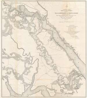
Campaign Maps Army of the Potomac Map No. 2 Williamsburg to White House Prepared by Command of Maj. Gen. George B. McClellan, U.S.A.
sold
- Digital Map Information
- Suitable for large format printing
- File Size: 16.56 MB
- File Type: ZIP / TIFF
- ICC color profile embedded
- Delivered instantly via download link
This is an 1862 separate-issue Henry Larcom Abbot map of part of the Virginia Peninsula during the American Civil War (1861 - 1865) commissioned by Union Major General George B. McClellan to illustrate the Peninsula Campaign. The map depicts from the James River to the York River, and from White House and the Richmond and York River Railroad to Williamsburg and the James River. This is the second in a series of three maps. Williamsburg, Virginia, the site of the first major pitched battle of the Peninsula Campaign, is located in the lower part of the map just right of center. Although the theater of war is illustrated, very few notations are present to indicate the state of war between Union and Confederate forces. Earthworks along the roads southeast of Williamsburg, known as Fort Magruder, are the only features that denote war. Roads, rivers, forests, and individual buildings however, are illustrated. (more details)