
Arthus-Bertrand, Claude (sold)

Claude Arthus-Bertrand (1769-1840) was a French army officer during the French Revolution. In the Napoleonic era, he founded a firm (Arthus-Bertrand, 1803 – present) that specializes in producing military medals, decorations, and insignia, often for the French government. Arthus-Bertrand was also an enthusiast of scientific expeditions and founded a publisher to promote them, which became the official editor of the Ministère de la Marine in the 1830s, where it oversaw the publication of the accounts of the 1836 – 1837 Bonite expedition that circumnavigated the globe.
Roadmap for Russia's conquest of Central Asia.
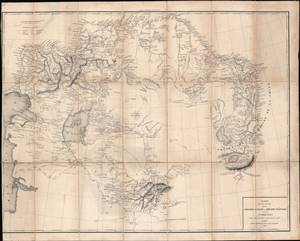
Carte du pays occupé par les Kirghiz - Kazaks ou Kirghiz - Kaissaks et du Turkestan.
sold
- Digital Map Information
- Suitable for large format printing
- DPI: 600
- File Size: 24.54 MB
- File Type: ZIP / TIFF
- ICC color profile embedded
- Delivered instantly via download link
This is the 1840 Claude Arthus-Bertrand translation of a Russian-language map of Central Asia by Aleksei Levshin, a pioneer in the study of Central Asia. The map was produced in the early stage of the 'Great Game', an imperial struggle between Great Britain and the Russian Empire over Central Asia. Given Arthus-Bertrand's connections with the French military and his firm's role as the official editor for the Ministère de la Marine, it is likely that this map was intended for use by the French military for intelligence purposes. (more details)
Monument to Captain James Cook in Hawaii, visited by a later expedition.
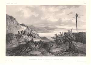
Monument élevé à Hawaii au Capitaine Cook, Iles Sandwich / [Monument raised in Hawaii to Captain Cook, Sandwich Islands].
sold
- Digital Map Information
- Suitable for large format printing
- Full resolution TIFF file
- ICC color profile embedded
- Delivered instantly via download link
This is a c. 1845 lithograph view of Kealakekua Bay, Hawaii (Sandwich Islands) illustrating a memorial to Captain James Cook, erected roughly where he was killed in 1779. The view was sketched by Théodore Auguste Fisquet, one of the resident artists on the Bonite expedition, a French scientific and diplomatic voyage around the world in 1836 - 1837. (more details)
One of the earliest obtainable views of Singapore.
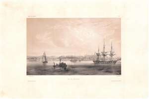
Vue de Sincapour.
sold
- Digital Map Information
- Suitable for large format printing
- DPI: 600
- File Size: 26.17 MB
- File Type: ZIP / TIFF
- ICC color profile embedded
- Delivered instantly via download link
One of the earliest obtainable views of Singapore, this is a rare c. 1845 chromolithograph by Barthélémy Lauvergne, one of the resident artists on the Bonite Expedition (1836 - 1837), a French scientific and diplomatic circumnavigation. It presents the British colony in its early days of development as a bustling port and meeting point of cultures. (more details)
View of Kealakekua and Kealakekua Bay, important sites in Native Hawaiian culture.
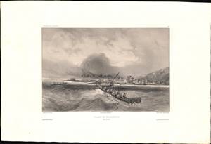
Village De Kearakekoua / [Kealakekua Village].
sold
- Digital Map Information
- Suitable for large format printing
- Full resolution TIFF file
- ICC color profile embedded
- Delivered instantly via download link
This is a c. 1845 lithograph view of the village of Kealakekua, Hawaii (Sandwich Islands) showing two groups of indigenous inhabitants in canoes with the village in the background. The view was sketched by Barthélémy Lauvergne, one of the resident artists on the Bonite expedition, a French scientific and diplomatic voyage around the world in 1836 - 1837. (more details)