
Basire, Isaac (sold)

Isaac Basire (September 20, 1704 - August 24 1768) was a London engraver, first in a family line of prolific and well-respected engravers. His most well-known work is the frontispiece to an edition of Bailey's 1755 dictionary but he was primarily a map engraver. He was born in London to on J. Basire, a Huguenot emigre from Rouen. His son James (1730-1802), grandson James (1769-1822), and great-grandson James (1796-1869) all continued the family trade. Assigning specific works to particular members of the family is not a straightforward task, as all four Basires were engravers, one often as apprentice to his father. Thus the work of the four frequently overlapped.
The Forge of the Gods.
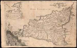
Sicilia.
sold
- Digital Map Information
- Suitable for large format printing
- Full resolution TIFF file
- ICC color profile embedded
- Delivered instantly via download link
This is Isaac Basire's scarce map of Sicily, Italy, with a vignette of Hephaestus' forge at work under the erupting volcano Mt. Etna. This detailed map of the island includes an inset in the upper left showing Sicily's position with respect to Carthage and Malta. The map is a copy of Christoph Cellarius' Sicilia Antiqua, published in his 1686 Geographia Antiqua. (more details)
Developing geographical knowledge in tandem with the slave trade.
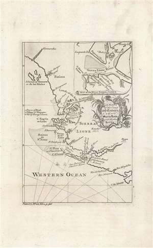
A map of the coast and country about Sierra Lione and Sherbro River.
sold
- Digital Map Information
- Suitable for large format printing
- DPI: 600
- File Size: 14.05 MB
- File Type: ZIP / TIFF
- ICC color profile embedded
- Delivered instantly via download link
This is a c. 1747 map and chart of the coast of Sierra Leone most likely engraved by Isaac Basire for John Green's A New General Collection of Voyages and Travels, published between 1745 and 1747. Made during the height of the Transatlantic Slave Trade, this map depicts the major source of slaves bound for the British colonies in America. (more details)