
Bauer, Hubert Anton (sold)

Hubert Anton Bauer (1882 – 19xx) was a German-American geographer and cartographer. Born in Germany, Bauer served in the German Merchant Marine for ten years, during which time he made nine trips around Cape Horn between 1905 and 1909. He then served in the German Navy for another four years. He came to the United States to earn his Ph.D., which he received from the University of Washington. After receiving his degree, he taught Earth Sciences at the University of Washington for a few years before accepting a position as a research supervisor to the Oregon State Planning Board, where cartography was one of his principal tasks. Then, he was selected as a consultant to the Alaska Planning Council and worked with the National Resources Planning Board in the Alaska Territory for four years, engaging in field work, research, and mapping. He worked for the Civil Aeronautics Administration during World War II and wrote and edited a series of aeronautical textbooks for Macmillan. His biography in his work Cartography (Map Making) summarizes his cartographic work quite nicely
Dr. Bauer is the author of numerous scientific articles on geographic topics, and of three books, one of them a brief treatise on cartography. Besides editing wall maps and charts for private map companies, he spent several years in independent cartographic work on numerous educational maps. Among his map products are modern air-age maps for the Air-Age Education Research, New York, a series of new map designs for the New Map of the Week, Inc., in Chicago, and a series of atlas maps for the revised J. Russell Smith geographies. He also prepared and edited for the Denoyer-Geppert Company, of Chicago, a series of four Meteorology Wall Charts which have become very popular with our air-minded school population.Bauer was a professor at Villanova University from at least 1950 until at least 1957.
Highlights the seven Latin American dictators that had been overthrown in the late 1950s and the Soviet rocket that was orbiting the Sun.
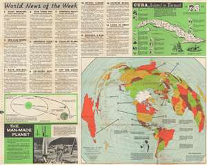
World News of the Week. Monday, Jan. 12, 1959 Covering Period Jan. 2 to Jan. 8 Volume 21 No. 21.
sold
This is a 1959 Hubert A. Bauer and News Map of the Week, Inc. map of the world chronicling the toppling of Latin American dictators from 1954 through 1959. A portrait of Fulgencio Batista, the ousted dictator of Cuba, occupies the southern Pacific Ocean and introduces the map's purpose - to detail the rise and fall of seven Latin American dictators from Cuba to Argentina. The other arrows, each numbered one through thirteen, indicate where the thirteen news stories summarized occurred. These include a landmark study of deep ocean trenches, the appointment of a cabinet in Cuba, a new U.S. national flag with a 49th star, a visit by the No. 2 Russian official Anastas Mikoyan to the United States, and a rebellion in Tibet. An inset, entitled 'Cuba, Island in Turmoil' provides a history of Cuba in thirteen vignettes. Profile views of the Cuban capital and Morro Castle are included as well. Bauer employs the azimuthal projection, developed by American Airlines. The projection allows the rendering great circle routes as straight lines. (more details)