
Benedicti, Heironymus (sold)

Heironymus Benedicti (c. 1756 - c. 1809) was an engraver based in Vienna that was active during the late 18th century.
Highlights several important locations during the first year of the Russo-Turkish War of 1787 - 1792.
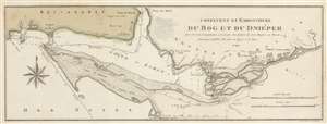
Confluent et Embouchure du Bog et du Dniéper pour Servir de renseignemens à la Carte de Limites de trois Empire ou Théatre de la Guerre de 1787 et 88 entre la Russie et les Turcs.
sold
- Digital Map Information
- Suitable for large format printing
- DPI: 600
- File Size: 15.06 MB
- File Type: ZIP / TIFF
- ICC color profile embedded
- Delivered instantly via download link
This is a 1788 Francois Joseph Maire map of southern Ukraine and Crimea during the first year of the Russo-Turkish War of 1787 - 1792. Depicting the region east of Odessa, the map stretches from the Gulf of Berezan to the Inhulets (Inguol) River and from Bessarabia to the Black Sea. The mouth of the Dnieper River is illustrated just to the right of center, and Russian military encampments are illustrated just up the river around Kherson (Cherson). Numerous depth soundings are noted near the river's mouth and up its course to Kherson. Depth soundings are also present in Dniprovs'ka Gulf (Golfe ou Liman). Two roads are illustrated on the Kinburn (Kinbourne) Peninsula that connect the Kinburn Fortress to a port on the Dnieper. The modern-day cities of Kherson (Cherson) and Ochakiv (Okzakow ou Otchakof) are labeled. (more details)