
Bennett, John (sold)

John Bennett (1746 - December 8, 1787) was an English map publisher. He was born in Derbyshire, the son of Tideswell shoemaker Samuel Bennett. He moved to London around 1761 to take work as a servant to the mapmaker Robert Sayer (1725 - 1794). In 1765, he became Sayer's formal apprentice. Bennett entered the Free Stationers guild on June 7, 1774. Bennett and Sayer continued to work together on the understanding that, in time, Bennett would acquire equity in the firm. This occurred in 1777, when the firm was renamed 'Sayer and Bennett'. For the next several years, they ran one of the most prolific map and printmaking firms in Europe. Bennett began to show signs of mental instability around 1781 and by 1783, was admitted to an asylum in Clapton. The causes are unknown, but mercury poising is a real possibility. Sayer petitioned to dissolve the partnership in 1784 and by 1785 there are no further publications bearing the 'Bennett' imprint. He died in Islington in 1787.
One the eve of the American Revolution.
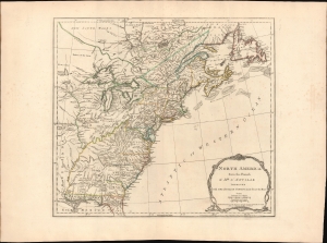
North America from the French of Mr. D'Anville improved with The English Surveys made since the Peace.
sold
- Digital Map Information
- Suitable for large format printing
- File Size: 26.39 MB
- File Type: ZIP / TIFF
- ICC color profile embedded
- Delivered instantly via download link
This is the 1775 Sayer and Bennett edition of Thomas Jefferys' map of the British Colonies in America, published on the eve of the American Revolutionary War (1775 - 1783). When this map was issued in June 1775, the Battles of Lexington and Concord had already occurred, and a formal Declaration of War from the Continental Congress was imminent. (more details)
Definitive field Atlas of the Revolutionary War.
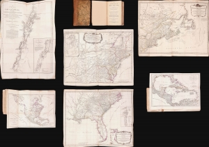
The American Military Pocket Atlas; being An approved Collection of Correct Maps, both General and Particular, of The British Colonies; Especially those which now are, or probably may be The Theatre of War.
sold
This is Sayer and Bennet's 1776 'Holster Atlas', one of the most sought-after cartographic works of the American Revolution. It was published at the beginning of the Revolution and presented as a collection of maps approved by British military authorities for use in the field. (more details)
First edition to name the United States.
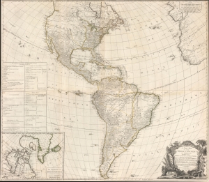
A New Map of the Whole Continent of America, divided into North and South and West Indies, wherein are exactly Described the United States of North America as well as the Several European Possessions according to the Preliminaries of the Peace singed at Versailles Jan. 20 1783.
sold
- Digital Map Information
- Suitable for large format printing
- DPI: 600
- File Size: 97.78 MB
- File Type: ZIP / TIFF
- ICC color profile embedded
- Delivered instantly via download link
A scarce 1783 Sayer and Bennett wall map of America issued shortly after the American Revolutionary War (1775 - 1783). This map followed closely on the Treaty of Versailles, which ended the Revolutionary War and established British recognition of the independent United States. This is the first issue of this map to name the United States - here, including all territory north of Florida, South of the Great Lakes (except Michigan), and east of the Mississippi. (more details)